Montréal Passenger Lists 1891-1960
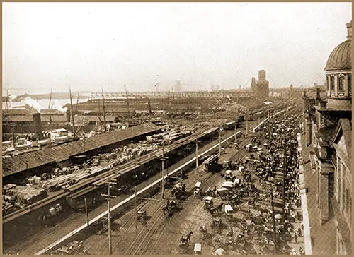
Harbor Scene at the Port of Montréal. The Entire Development of Montréal Is Hampered to Some Extent by the Lack of Attention Given to St Lawrence by the Dominion Government. It Is Pleasing To Know That This Is To Be Changed, the Shipping Federation of Canada Having Received an Assurance That the Work of Deepening the Ship Channel to 40 Ft . With a Width Necessary To Accommodate the Growing Size of Ocean Steamships Is To Be Proceeded With. The Syren & Shipping Illustrated, 24 June 1908. GGA Image ID # 147322257a
Montréal is a city in the Canadian province of Québec. It is the largest city in the province, the second-largest in the country (after Toronto) and the fifteenth-largest in North America.
The city proper covers most of the Island of Montréal at the confluence of the Saint Lawrence and Ottawa Rivers. The port of Montréal lies at one end of the Saint Lawrence Seaway, which is the river gateway that stretches from the Great Lakes into the Atlantic Ocean.
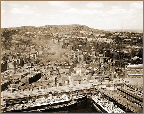
Two Ocean Liners Docked in this View of the Port of Montréal, 1925. GGA Image ID # 1d4616be7a
The Port of Montréal, Québec (1937)
Montréal is situated at the head of the improved ship channel of the St. Lawrence River. The minimum width of the channel between Québec and Montréal is 450 feet, while it is 1,000 feet below Québec. The channel to Montréal has been dredged to a depth of 30 feet below the shallow water of 1897.
The harbor is divided into three sections:
- The upper section south of the Lachine Canal
- The central harbor
- The lower section
Opposite the city are three islands, known as Ile Verte, Ile Ste. Helene, and Ile Ronde. The main ship channel passes on the west side of these islands.
Under its position at the head of ocean navigation, Montréal has easily maintained its supremacy among the ports of Canada. It handles a larger share of Canadian and American traffic, including grain and miscellaneous freight moving to and from the Chicago district and other points in the West.
The Canadian Pacific and National Railways serve the port, constituting Canada's two critical trunk line systems. It is the lower terminus of the St. Lawrence canals, utilizing which it receives large quantities of grain and other commodities.
The entire port's waterfront is controlled by the National Harbor Board, which operates the facilities, including a belt line railway connecting them with the rail carriers. This control has enabled the port to proceed systematically with a comprehensive port development plan.
One of the outstanding features is the provision for supplying grain to vessels at their regular berths, employing an extensive system of galleries communicating with the harbor commission's elevators.
While the maintenance and operation of this gallery system constitute an added expense in the loading out of grain as compared with elevators having loading spouts directly from the shipping bins, it is an expense that is justified by the advantages it possesses in lessening the time and cost of the ship in port.
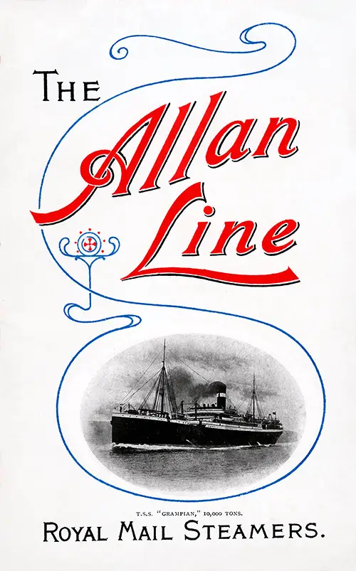
Front Cover, TSS Grampian of the Allan Line, 1909. GGA Image ID # 1d45bb7627
======== 1890s ========
Allan Line Royal Mail Steamers
======== 1900s ========
Allan Line Royal Mail Steamers
Dominion Line
======== 1910s ========
Allan Line Royal Mail Steamers
Canadian Pacific Line
Cunard Line
Donaldson Line
White Star Line

Front Cover, Cunard Line RMS Ascania Passenger List, 1925. GGA Image ID # 1d45bc4974
======== 1920s ========
Anchor-Donaldson Line
Canadian Pacific Line
- 1921-05-28 SS Melita - Montréal to Liverpool
- 1921-09-06 SS Metagama - Liverpool to Québec and Montréal
- 1922-06-24 SS Corsican - Montréal to Glasgow
- 1923-06-22 SS Montrose - Liverpool to Québec and Montréal
- 1923-07-13 SS Montcalm - Liverpool to Québec and Montréal
- 1923-08-17 SS Metagama - Glasgow to Québec and Montréal
- 1924-05-23 SS Marloch - Glasgow to Québec and Montréal
- 1925-09-11 SS Marburn - Glasgow to Québec and Montréal
- 1926-06-30 SS Melita - Antwerp to Québec and Montréal
- 1927-07-29 SS Montclare - Liverpool to Québec and Montréal
- 1928-05-04 SS Minnedosa - Liverpool to Québec and Montréal
Cunard Line
- 1923-06-08 RMS Andania - Southampton to Québec and Montréal
- 1924-07-10 RMS Antonia - Cherbourg to Québec and Montréal
- 1924-08-01 RMS Andania - Southampton to Québec and Montréal
- 1925-07-11 RMS Ascania - Montréal to London
- 1925-08-15 RMS Ausonia - Southampton to Québec and Montréal
- 1925-08-21 RMS Alaunia - Liverpool to Québec and Montréal
- 1928-05-04 RMS Ausonia - Southampton to Québec and Montréal
- 1928-08-17 RMS Andania - Liverpool to Québec and Montréal
- 1929-09-29 RMS Ausonia - Southampton to Québec and Montréal
White Star-Dominion Line
White Star Line
- 1927-04-16 RMS Doric - Liverpool to Québec and Montréal
- 1927-09-09 RMS Albertic - Liverpool to Québec and Montréal
- 1928-05-19 RMS Doric - Montréal to Liverpool
- 1928-06-14 RMS Albertic - Montréal and Québec to Southampton
- 1928-08-17 RMS Laurentic - Liverpool to Québec and Montréal
- 1928-09-14 RMS Laurentic - Liverpool to Québec and Montréal

Front Cover, RMS Alaunia of the Cunard Line Passenger List, 1925. GGA Image ID # 1d45edc8a9
======== 1930s ========
Anchor-Donaldson Line
Canadian Pacific Line
- 1931-09-04 SS Duchess of Bedford - Liverpool to Québec and Montréal
- 1932-09-09 SS Duchess of Atholl - Liverpool to Québec and Montréal
- 1932-10-14 SS Duchess of Bedford - Liverpool to Québec and Montréal
- 1933-05-12 SS Duchess of Atholl - Liverpool to Québec and Montréal
- 1937-08-17 SS Duchess of Richmond - Southampton to Québec and Montréal
- 1937-09-24 SS Duchess of Atholl - Montréal to Liverpool
- 1938-08-19 SS Duchess of Bedford - Liverpool to Québec and Montréal
- 1939-08-04 SS Montrose - Liverpool to Québec and Montréal
Cunard Line
- 1930-06-20 RMS Aurania - Montréal to London
- 1930-07-12 RMS Ascania - Southampton to Québec and Montréal
- 1930-09-20 RMS Ausonia - Southampton to Québec and Montréal
- 1931-06-12 RMS Antonia - Liverpool to Québec and Montréal
- 1932-06-04 RMS Ausonia - Southampton to Québec and Montréal
- 1932-09-10 RMS Aurania - Southampton to Québec and Montréal
- 1933-04-21 RMS Alaunia - Montréal to London
- 1934-04-28 RMS Antonia - Liverpool to Québec and Montréal
- 1936-07-31 RMS Antonia - Liverpool to Montréal and Québec
- 1937-08-07 RMS Ausonia - Southampton to Montréal and Québec
- 1938-08-27 RMS Alaunia - Southampton to Québec and Montréal
- 1938-10-15 RMS Ausonia - Southampton to Montréal and Québec
Donaldson Atlantic Line
White Star Line
Front Cover, Cunard Line RMS Aurania Passenger List, 1930. GGA Image ID # 13073e8e31
======== 1940s ========
Canadian Pacific Line
======== 1950s & 1960s ========
Canadian Pacific Line
Cunard Line
Note: Typically, only the origination and final destination ports are listed in each link. Other intermediary ports of call are not listed.
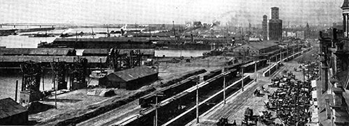
The Harbour at Montréal, The Great Port on the St. Lawrence. Canada Today, 1913. GGA Image ID # 14c763b1d2
Although closed to navigation over four months of each year by the freezing of the St. Lawrence River, Montréal far surpasses other Canadian ports in volume and value of traffic. Its favored geographic location, at the head of ocean navigation on the St. Lawrence and the foot of inland navigation of the Great Lakes, has made this port the converging point for railroads, ocean steamers, and Great Lakes vessels.
Therefore, it is an economical and convenient transshipping center for exports from and imports to eastern and central Canada. Montréal's grain export trade holds the first rank among world ports: millions of bushels are transshipped annually from lake and rail carriers to ocean steamers destined principally for Europe.
Montréal's port commands the shortest and cheapest trade route to Great Britain. It has possibilities for a Canal and River system for tapping the trade of almost the entire continent. It is a national duty that full advantage be taken of this geographical position to build up an all-Canadian water route between the Great West and Montréal capable of handling Canada's exports and imports through Canadian seaports and also enabling us to compete successfully for the American trade from the Great Lake ports, which are tributary to this route.
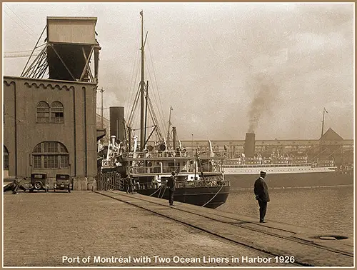
The Port of Montréal with Two Ocean Liners in Harbor, 1926. GGA Image ID # 1d46701795
Related Categories
Ephemera & History
- Allan Line Royal Mail Steamers
- Anchor-Donaldson Line
- Canadian Pacific Line
- Cunard Line
- Dominion Line
- Donaldson Atlantic Line
- Donaldson Line
- White Star-Dominion Line
- White Star Line
Steamship & Ocean Liners
- Alaunia
- Albertic
- Andania
- Antonia
- Ascania
- Athenia
- Aurania
- Ausonia
- Canada
- Cassandra
- Corsican
- Dominion
- Doric
- Duchess of Atholl
- Duchess of Bedford
- Duchess of Richmond
- Empress of Canada
- Empress of France
- Grampian
- Ivernia
- Laurentic
- Letitia
- Marburn
- Marloch
- Megantic
- Melita
- Metagama
- Minnedosa
- Montcalm
- Montclare
- Montrose
- Parisian
- Pretorian
- Victorian
- Virginian
SS RMS MV - Defined
Corps of Engineers, United States Army, "Montreal, Quebec," in Transportation on the Great Lakes, Transportation Series No. 1 (Revised 1937), Washington, DC: US Government Printing Office, 1937. p. 252
