Port of Baltimore and Harbor

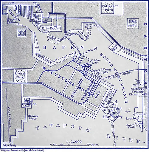
Map of Baltimore Harbor, 1892. Der Norddeutscher Lloyd, 1892. GGA Image ID # 216263775d

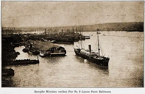
Norddeutscher Lloyd Steamer München Leaving Pier No. 9, Locust Point, Baltimore. Der Norddeutscher Lloyd, 1892. GGA Image ID # 2162711201

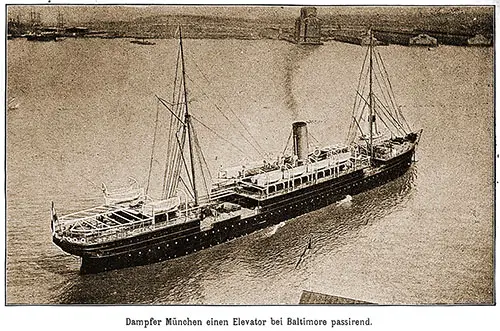
The Steamer München Passes an Elevator New Baltimore Harbor. Der Norddeutscher Lloyd, 1892. GGA Image ID # 216290a861
THE PORT OF BALTIMORE, MD. PORT AND HARBOR CONDITIONS
GENERAL DESCRIPTION
Baltimore is situated at the head of tidewater navigation on the Patapsco River, about 12.5 miles from Chesapeake Bay and 170 statute miles from the Virginia capes. The city covers an area of 91.93 square miles. Its population, according to the United States census of 1930, was 804,874. The harbor consists of the Patapsco River and its tributaries. A portion of the water front thus included lies outside of the municipal limits, but the State legislature has by law extended the jurisdiction of the Bureau of Harbors of Baltimore city to include the entire river and its tributaries.
The Patapsco rises in Maryland and above Baltimore is a flowing stream of fair size but of insignificant commercial importance. In the city the character of the stream changes as it empties into the navigable tidal estuary of the same name. This is from three fourths of a mile to over 4 miles wide. There are three principal arms or branches of the lower river, called the Northwest Branch, Middle Branch, and Curtis Bay, which form important sections of Baltimore Harbor.
The Northwest Branch (inner harbor) lies inside of Fort McHenry and Lazaretto Point and penetrates into the center of the city at the Light Street wharves. It is about 3 miles long and varies in width from 800 to 3,000 feet. The Middle Branch (also called Spring Garden) extends from Ferry Bar to the foot of Eutaw Street and is about 2 miles long and from 1,200 to 2,500 feet wide. Curtis Bay lies on the south side of the Patapsco River about 8 miles above the mouth and is about 1 1/2 miles long and three fourths of a mile wide. There are several other branches of the river of lesser importance.
CHANNEL IMPROVEMENTS BY THE UNITED STATES
Baltimore Harbor has been under improvement by the United States since July 4, 1836, the date of the original project. The present Federal improvement project provides for a minimum depth of 37 feet from the sea to Sparrows Point, thence of 35 feet for about 7# miles to Fort McHenry. Natural depths in excess of this are found in Chesapeake Bay from the entrance between Cape Charles and Cape Henry to a shoal area off York Spit, Va., about 158 statute miles from Baltimore. A dredged channel 3 miles long, 37 feet deep, and 1,000 feet wide has been completed through this shoal area. From the northern end of this channel to a point off the mouth of the Maggoty River, some 20 miles below Fort McHenry, the natural depths in the bay are greater than 37 feet. The main dredged ship channel from Chesapeake Bay into Baltimore starts at this point and is 37 feet deep and 600 feet wide in the straight reaches and wider at the turns to Sparrows Point, thence it is 35 feet deep. The upper end of this channel is at Fort McHenry.
The Federal project also includes three dredged anchorages, each of which is completed and is 35 feet deep. The lowest of these is the quarantine anchorage, which is on the southwest side of the main channel, opposite the quarantine station. It is 3,500 feet long, 600 feet wide outside of channel limits, and has an area of about 48 acres. The Fort McHenry anchorage is located south of Fort McHenry near the upper end of the main channel and southwest thereof. It is 3,500 feet long and 400 feet wide outside of channel limits and has an area of approximately 36 acres. The Riverview anchorage is on the northeast side of the main channel just below Fort McHenry anchorage and is 4,500 feet long, 1,500 feet wide outside of channel limits, and contains about 155 acres.
Two branch channels included in the Federal project lead to important sections of the harbor. One of these diverges from the main channel at the upper end of the quarantine anchorage and leads into Curtis Boy. This channel, which was completed in 1931, is 2% miles long, 35 feet deep, and 400 feet wide, with a turning basin at the inner end. The other branch channel extends from the upper end of the main channel, post Ferry Bar, and into the Middle Branch. The authorized dimensions are 35 feet deep and 400 feet wide os far as Ferry Bar, thence 27 feet deep and 250 feet wide to the Western Maryland Railway bridge, with a turning basin at the upper end. At the present time this channel is open and in use as far as the Hanover Street Bridge, with a depth of 35 feet and a width of 400 feet from the main channel to the Port Covington entrance and thence is 150 feet wide to Ferry Bar, and a depth of 27 feet and a width of 150 feet from Ferry Bar to Hanover Street Bridge. Above the Hanover Street Bridge the old Spring Garden Channel, constructed under a previous project, is still in use. It is 100 feet wide and about 22 feet deep. No further improvement of the Middle Branch above the Western Maryland Railway bridge is contemplated by the United States. The Federal project also provides that as fast as the city of Baltimore shall extend the 35-foot depth from the upper end of the main channel into the Northwest Branch the United States shall assume the maintenance of this depth. The city has, up to the present time, made such extensions along the water front at Canton and at Locust Point, which are occupied by the terminals of the Pennsylvania and the Baltimore & Ohio Railroads, respectively.
Traffic from Baltimore to the north via the inland route uses the Chesapeake and Delaware Canal connecting Chesapeake and Delaware Bays. This was formerly a privately owned lock canal 17.9 miles long. It has been purchased by the United States and transformed into a sea-level canal 12 feet deep and 90 feet wide at the bottom.
The open bay, the approach channels to the port of Baltimore, and the channels within the harbor are all amply marked by the aids necessary to insure safe navigation.
CHANNEL IMPROVEMENTS BY THE CITY OF BALTIMORE
All of the work of channel improvement in the Northwest Branch has been done by the city of Baltimore at its own expense. The 35- foot depth has been extended from the upper end of the channel of that depth dredged by the United States, past the overseas piers of the Baltimore & Ohio and Pennsylvania Railroads, to a line between the outer end of Henderson’s Wharf, Fells Point, and Hamilton’s coal pier, Locust Point, where it is joined by a 24-foot extension channel serving the municipal piers along Pratt Street and the bay and river line wharves along Light Street. The city has also dredged a channel 27 feet deep from the upper end of the 35-foot area to the heads of the slips on both sides of the municipally owned Broadway Pier, and a channel 30 feet deep in front of the American Sugar Refining Co.’s wharf at Locust Point. As has been previously stated, the United States, under the existing project for improvement, assumes the maintenance of the 35-foot areas in the Northwest Branch as soon as the original dredging to extend that depth from the main ship channel has been done by the city. The city maintains the areas of lesser depth. There is no definite municipal program for channel extension at the present time. The original channel from Fort McHenry into the Middle Branch was dredged by the city and later taken over by the United States. The upper end of this channel, above the Hanover Street Bridge, is still in use, but the lower portion has been superseded by the channel provided under the existing Federal project.
PUBLIC TERMINAL IMPROVEMENTS
The city of Baltimore owns a group of coastwise piers at the head of the Northwest Branch occupying the entire north side of the basin along Pratt Street. One of these piers is held jointly by the city of Baltimore and the State of Maryland. These piers and two erected along Lancaster Street are used principally for the storage of lumber. Broadway Pier was erected by the city as a recreation and commercial pier and the lower deck is used as a storage warehouse for import and export freight. The majority of the piers along Light Street, at the head of the basin, are owned by the municipality. These are leased to established steamboat companies, who use them for bay and river terminals.
Preliminary steps have been taken looking to an extensive development of terminals owned or controlled by the municipality. A law, passed by the General Assembly of Maryland and approved April 9, 1920, authorized the mayor and the city council of Baltimore to incur indebtedness to an amount not exceeding $50,000,000 “for the purpose of developing, extending, and improving the harbor of Baltimore and its facilities”, and granted the incidental power necessary to carry out the intent of the act. The port development commission was established by the city to control the expenditure of this fund.
The first installment of $12,500,000 of this loan was made available and $8,500,000 was spent in constructing an ocean terminal for the Western Maryland Railway Co. at McComas Street, the railway company paying a rental to cover the interest and sinking fund charges.
TIDES
The mean range of tides in Baltimore Harbor is 1.2 feet, and at York Spit light 2 feet. Just outside the Patapsco River, at Seven Foot Knoll, the mean range is about 0.9 of a foot, and at other points in the bay it is variable between these heights. Prolonged winds of constant direction may cause substantial variations from these averages. The extreme range reported to have occurred within Baltimore Harbor was between a tide of 6.8 feet above and one of 4.5 feet below mean low water. This, however, was exceptional. The ordinary maximum range is from 5 feet above to about 3 feet below mean low water.
PORT CUSTOMS AND REGULATIONS
FEDERAL SERVICES AND REGULATIONS
A digest of the more important regulations of the Public Health Service (quarantine and hospital service), the Customs Service, and the Immigration Service, and information relative to their services and charges applicable to vessels, freight, and passengers, aro contained in Miscellaneous Series No. 1, entitled “Port and Terminal Charges at United States Ports.” A list of the Federal documents which vessels are required to have is also included in Miscellaneous Series No. 1. This volume, which may be obtained from the Superintendent of Documents, Government Printing Office, Washington, D.C., is revised annually. Miscellaneous Series No. 2, published in 1928 and entitled “Shipping Charges at United States and Foreign Ports,” contains information relative to the services and charges of United States consular officers abroad and of foreign consular officers stationed at the various seaports of the United States. This is also obtainable from the Superintendent of Documents, at a price of 25 cents.
Public Health Service, Treasury Department
Quarantine.—The quarantine station is situated at Leading Point, on the west shore of the Patapsco River at the mouth of Curtis Bay, about 7 miles below the center of the city. The station is thoroughly modem and is equipped with hospital facilities for the detention of contagious and infectious disease cases removed from vessels. Sendee is maintained from sunrise to sunset and is extended to midnight when necessary.
Hospitals.—In addition to the quarantine station, the Public Health Sendee operates a marine hospital and a dispensary. The former is United States Marino Hospital No. 1 and is located at Remington Avenue and Thirty-first Street, in the northern section of the city about 3 miles from the water front. The dispensary is located in the basement of the customhouse, within a few hundred feet of the Pratt Street piers.
The city of Baltimore is amply provided wdth public and private hospitals and dispensaries.
Immigration Service, Department of Labor
The Federal Government has erected a modern immigration station on the Fort McHenry reservation on the north side of Whetstone Point. Immigrant travel to Baltimore has not been resumed since the War.
Customs Service, Treasury Department
The United States Customs District of Maryland comprises the ports of Baltimore, Crisfield, Annapolis, and Cambridge, Md., and Washington, D.C. The organization of the customs service for the district of Maryland consists of a collector, a comptroller, a surveyor, and an appraiser, who are administrative officers appointed by the President of the United States. The collector is the executive officer of the district. The comptroller is the auditor for the collector and his operations extend to other collection districts, for which he is also the auditor. The surveyor is the supervising officer of the entire outside force of inspectors, weighers, and laborers, and he supervises the entry or clearance of cargoes at all ports in the district. The appraiser places the value upon goods upon which duty is collected by the collector.
The customhouse is located at the comer of Gay and Lombard Streets, less than 500 feet from the north shore of the basin, where, however, there is but little foreign shipping. The majority of foreign commerce is carried on at Locust Point, Port Covington, Canton, Lower Canton, Curtis Bay, and Sparrows Point, where the principal overseas terminals are situated. The customhouse may be reached from any of these sections by street railway service.
The customhouse is open from 9 a.m. to 4:30 p.m. on all days but Saturday and Sunday. On Saturday it is open from 9 a.m. until the business of the day is completed, which is usually about 1 p.m. If business demands an extension of these hours for the benefit of the shippers and merchants, it is granted. The working hours established for customs inspectors arc from 8 a.m. to 5 p.m. These hours are extended upon request to any time during the night and Sundays and holidays, but extra compensation is charged by the inspector rendering the service.
Bibliography
The Board of Engineers for Rivers and Harbors, War Department, and Bureau of Marine Development - United States Shipping Board, "Part I (Revised 1933) The Port of Baltimore, MD," in Port Series No. 16: The Ports of Baltimore, MD, Washington DC, and Alexandria, VA. United States Government Printing Office, Washington, 1934.
