
The Port of Rotterdam

The Masshaven, 148 acres in area with 28 feet depth of water, is a busy place, filled with seagoing steamships and river boats. GGA Image ID # 1421fd7eac
Rotterdam is, par excellence, a "transit port." It is one of the main gates of entrance to and egress from the interior of Europe and an entrepot or transshipping station for the merchandise of the world.
REAL CHEAPNESS—that is economic cheapness—cannot exist without efficiency. So it is that the great Hollandish port of Rotterdam, while maintaining its traditions for cheapness, embodies also in its claim that of the reputation for highest efficiency.
The growth and development of Rotterdam in its various maritime functions has, written the last thirty years or so, been remarkably rapid. Thus comes about that appearance of extreme modernity which at once strikes the visitor who for the first time arrives there and even those who revisit it after the in absence of even a decade.
Indeed, its progress within the last few years has been phenomenal and is at once a cause of real pride among its sturdy burghers and real value to its world-renowned mercantile colony.

Map of the Port of Rotterdam and Surrounding Area. Rotterdam Serves a Great Area North of the Alps and as far East as Budapest. GGA Image ID # 1422404b8a
Rotterdam is, par excellence, a "transit port." It is one of the main gates of entrance to and egress from the interior of Europe and an entrepot or transshipping station for the merchandise of the world.
For return freights the exports of the Netherlands are of great importance. If a shipowner knows that there is a good chance of his ship being reladen at the port of discharge, he can fix his rates of freight to that port with every confidence of not having to bring back his ship with an empty hold. Such advantages at a port reduce freights each way and lead to increased business, to the benefit of all concerned.
In former times, when England was the "workshop of the world," a great traffic flourished via Rotterdam between Great Britain and Central Europe. In later times, as the absence industries of Germany and Austria developed, Rotterdam became the shipping port for the manufactured goods of those countries.
Rotterdam was, before the change in Dutch colonial policy, the great emporium or market of the colonial trade. After the introduction of tariff reform, Rotterdam gave place to Amsterdam in this respect and it was not until Rotterdam opened up permanent steamship connections with New York (with the Holland-America Line in 1873) that she indemnified herself for what she had lost, mainly through financial and marketing operations, to the capital.
In consequence of this development, Rotterdam grew in importance in the transit of American goods.

Modern Freight Handling Machinery is much in Evidence Along the Rotterdam Waterfront. GGA Image ID # 142266d149
The oleomargarine market was established, and it developed rapidly until the city became the center of the trade in the materials used in the manufacture of margarine, etc.
Farmers have found at Rotterdam a flourishing outlet for their produce of all kinds and. in consequence of the enormous quantities of heavy goods which pass through the port, many great mercantile houses have been established there.
The immense volume of trade done at Rotterdam may be most clearly indicated by a comparison of tonnage at the big ports of Europe. The leading ports of Europe are, in order of importance: London, Liverpool.
Hamburg (before the war). Antwerp, and Rotterdam. Leaving out of consideration the British ports, we find that in 1913 the net registered tonnage of inward bound vessels was in the neighborhood of 14,150,000 tons at Hamburg and Antwerp and 12,750,000 tons at Rotterdam.

The SS Nieuw Amsterdam and the SS Roterdam Shown Alongside the Loading Berth of the Holland-America Line in Rotterdam. GGA Image ID # 14230cb6b6
In regard to the calculations at Antwerp it is necessary to deduct 15 percent to bring the total in line with those for Hamburg and Rotterdam. A striking fact that evolves from a comparison of tonnage is that Rotterdam.
Hamburg and Antwerp have each multiplied their traffic nine times in the period from 1870 to 1910.
Another result of this growth of traffic was to attract important manufacturing firms to establish their works adjacent to the port so as to eliminate wasteful haulage.

Electric Traveling Cranes for Handling Cargo on the Pier of the Rotterdam Lloyd. GGA Image ID # 14232738fb
These works are many and varied in their scope and have taken location at Rotterdam within the past thirty-five years or so. Prior to this development, Rotterdam had not much in the way of industrial works beyond several distilleries.
Communication by water and railway being cheap, the establishment of the many direct steamship routes with transatlantic countries and elsewhere has had a corresponding benefit upon manufacturing works in other parts of the country.

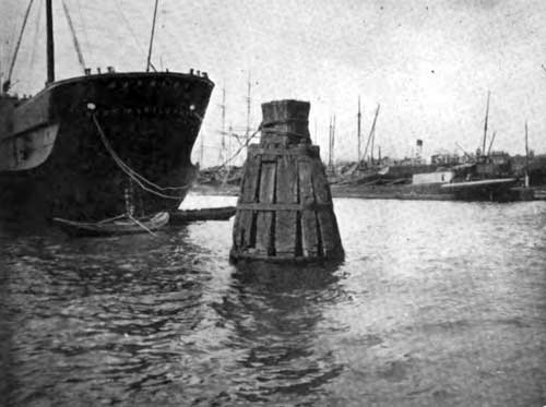
Grain Elevator and Storage Warehouse in the Maashaven. GGA Image ID # 1423656832
Shipbuilding and Repairing
In the seventeenth century, shipbuilding flourished in Rotterdam, but it waned with the advent of steam and the resuscitation of this great industry did not take place until comparatively recent days.
When the renewal did come, it developed with the genius of the Hollander in the path of his unique experiences. One firm, J. and K. Smut, applied themselves to building dredgers and sandsuckers and by the manufacture of these vessels or implements, indispensable to all engineering and navigation works in a country like Holland, they became famous.

Wilton's Engineering & Slipway Company Ship Repair Yard in Rotterdam. 4 Pontoon Docks for Ships from 4,500 Tons up to 46,000 Tons. Sideslip for Steamers up to 300 Feet in Length. GGA Image ID # 14238ad92f
Ship repairing became a specialty at Rotterdam and the nature of the country led to the adaptation and development of floating dry docks.
The shipyards and engineering works at Rotterdam are world famous and comprise the well-known firms of: A. F. Smulders, (Werf Gusto) shipbuilders and engineers who specialize in the manufacture of electrically driven derricks, revolving and self-propelling floating cranes, etc.; Wiltons Slipway and Engineering Works, one of the most important of Rotterdam ship repair firms; The Rotterdam Dry Dock Co., builders and repairers of all classes of merchant ships. This firm owns two floating dry docks with lifting capacities of 5,500 and 8.S00 tons; the New Waterway Shipbuilding Co, Schiedam and the Burgerhouts Shipbuilding and Engineering Works, of Rotterdam.
Unique Mooring Methods
The use of mooring posts on the banks and quay walls at Rotterdam is avoided as much as possible. It is not deemed advisable to have the strain of seagoing or heavy craft adding to the many forces acting on the walls. Special mooring posts are provided at the newer quays and there are also towers in certain positions and numerous dolphins and mooring buoys for ships in mid-stream.

Storage Tanks and Wharves Extend for more than a Mile on the South Bank of the Maas. Rotterdam Now Ranks as One of the Foremost Oil Ports of Europe. GGA Image ID # 14239230cc
The resource and ingenuity with which the engineers of Holland conquer the natural difficulties and problems that beset them compels the admiration of all who have the good fortune to visit the Netherlands and especially the splendid docks and harbor works at Rotterdam.
Storage Facilities
Warehouses built on the waterside are rare and are found only at the south side of the Scheepmakers harbor. Goods are mostly stored in merchants' premises.
For a long time, the regular steamers which used the quays on the right bank of the Maas had to discharge their cargoes upon the open quays but these services have for some years been accommodated at the other harbors where serviceable sheds are provided.

The Port of Rotterdam's Bunkering Facilities Include Electrically Operated Car Unloaders. GGA Image ID #s 1423b0ac9e
At present there are gigantic warehouses belonging to various authorities situated on or in the immediate vicinity of deep water. These establishments are distinguished as follows: Free Bonded Warehouses, under the control of the Municipality and the Custom House authorities: Private Free Bonded Warehouses, for goods liable to high duty. These are owned by private firms but entirely under the control of the Customs.
Fictitious Bonded Warehouses, for goods liable to low duties. The customs-authorities confine themselves to controlling the quantities stored from time to time and they have not the disadvantages of continual supervision.

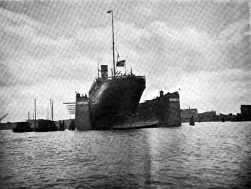
The Ocean Liner SS Nieuw Amsterdam in Drydock, with Wilton's Floating Crane "Titan" in Attendance. GGA Image ID # 1423baa007
Warehouses free of the customs control and available for duty free goods or goods upon which duties have been paid.
There are many firms and corporations undertaking warehousing and forwarding of merchandise.
Inland Water Communications
Situated on one of the mouths of the Rhine, the state of that river and its future management is of vital consequence to Rotterdam. Communication with Germany is principally secured via the New Meuse, the Noord, the Merwede.
The Waal and the Upper Rhine. As far as Mannheim, the Rhine is navigable for vessels of about 1,500 tons burden and thence to Strasburg, for the greater part of the year, for vessels of 800 tons. The Main is also navigable as far as Frankfort with ships of 1,500 tons.

The Dutch Floating Grain Elevator Differs Greatly in Appearance from the Familiar American Type. GGA Image ID # 1423c15a1b
Rotterdam serves as a port for the Rhine provinces, the Palatinate, Baden, Alsace, Lorraine and partly for the North of France and Belgium, though the latter countries are, of course, more closely associated with Antwerp.
Communication by water with Amsterdam is maintained both via Gouda and Garinchem. Along the Merwede Canal large Rhine craft keep up communication between Holland's two seaports.
The South Holland canal system is mainly centered upon Rotterdam which is regarded by the inhabitants of many of the outlying districts as their natural market town.
Area of Docks and Quays
At present the dock area on the right bank of the Maas totals 202 acres, with public quays to a length of 13 1/2 miles.
The dock area on the left bank of the Maas amounts to 737 acres with 15 miles of public quays. On the two sides together the dock area is 939 acres and the length of the quays 28 1/2 miles.
Dock Appliances
The supply of mechanical appliances for the docks is a question that has continually occupied the attention both of the authorities and private firms, and this matter has been taken in hand energetically by the one or the other, especially during the last few years.

Rotterdam is Equipped with the Most Modern Devices for Transshipping Coal and for Bunkering Steamships. GGA Image ID # 1424399ae5
They are fully alive to the fact that good channels to the sea and extensive inland canals are alone insufficient to deal with the immense masses of goods in transit, if freight rates are to continue competitive.
The seagoing ship must be able to discharge as rapidly as possible and at the same time be assured of a freight for the return voyage, so that she will have to remain in port only a short time and not be compelled to return in ballast.
Along the quays and wharves there are some 140 cranes available for loading and unloading ships, the greater number being the property of the town. The lifting capacity varies from 1 1/2 to 30 tons, while for motive power, water pressure, steam and electricity are used.

The Long, Low, Capacious Steel Barge of the Dutch Canals and Rivers Looks Strange to Our Eyes, but Her Type Deserves Study. GGA Image ID # 14248a41ba
Since 1890, electric cranes have taken the foremost position, Rotterdam having been the pioneer in their employment.
Of late years special attention has been devoted to floating hoists. The ordinary cranes of this kind have a lifting capacity varying from sixteen to a hundred and twenty-five tons.
The smaller ones are generally of very simple construction. On account of their odd appearance, some of them have been given curious names, such as Bison, Giraffe, etc.
Up to within a short time ago, manual labor was the only means available for handling grain, of which, in 1913, five thousand two hundred million kilograms were imported.
The work is now mostly done by machinery. In addition to the "Jacob's ladders" attached to warehouses or which can be placed in ships, thirty floating grain elevators, with a capacity of 150 to 200 tons an hour each, are now in use.

Bunkering the Mail Steamer "Koningen der Nederlanden at Rotterdam. GGA Image ID # 1424f3aa37
Great disturbances accompanied the introduction of these elevators, in 1907, but the flow of grain to Rotterdam (in 1913 to a value of nearly three hundred million guilders) was a powerful argument in favor of their introduction. The erection of grain warehouses and automatic chutes has kept pace with the increased' import of grain.
Rotterdam as a Coal Port
The transport of coal via Rotterdam also increased in the last few years before the war, about seven million tons having passed through the port in 1913, including about five million tons imported from Germany.
Coal tips for the quick discharging of railway cars have been in use for several years on the wharves. The floating loading and unloading machinery is of later date, but exceeds in importance the stationary machinery. There are a large number of floating slewing cranes with grabs, those of recent construction being provided with tipping and weighing apparatus.

Coaling the SS Macedonia - Bunkering at Hook of Holland Coaling Station. GGA Image ID # 1425095595
The most modern devices for the transshipment of coal, and especially for the bunkering of passenger and freight steamers, are the transporters and elevator-transporters.
The Pluto, Prosper and Harpen are transporters which have their own coal holds. Their capacity is 600 to 700 tons and they are able to bunker seagoing ships at the rate of 250 tons of coal per hour, without interfering with the loading and discharging of cargo.
The Holland and Westfalen, which are a combination of bucket elevator and transporter, have no coal hold and therefore take the coal direct from the collier. Their capacities are 670 and 1,050 tons per hour.
Eight overhead cranes, running on a track, deserve special notice. They are erected on the Maas Dock and are used for discharging cargoes from ships into railway cars direct, as well as from seagoing vessels into Rhine barges and vice versa.
In conclusion we wish to express our thanks and appreciation to the Burgomaster, Dr. A. R. Zimmerman, the Chief Engineer of the Harbor department and Public Works, the Chamber of Commerce and all concerned, for their help and courtesy so readily extended to us in the compilation of the foregoing.
Port of Rotterdam: Unique Nautical Museum and Library (1922)
THERE is something very misleading to strangers in the title of the National Technical and Nautical Museum in Rotterdam. It is not a museum at all, but the center of all those forces that go to develop the scientific, technical and commercial sides of the Dutch shipping industry.
Shipping interests in Rotterdam are more intense and more varied than those in any other European port. There are no less than one hundred and six separate shipbuilding and repairing yards, and vessels from all corners of the world use the very up-to-date facilities for docking and cargo handling offered by the port.
The center of shipping interests is in the hands of J. W. J. Baron van Haersolte, the director of the museum. The first factor in its success Is the versatility of its director, who keeps the collection of models and processes and engines right up to date. He also organizes an extensive library, with the current shipping and technical literature and newspapers of Europe, arranges lectures and meetings of the various shipping associations In the port.
Demonstrations of new inventions for shipping and engineering are given at the museum, and Baron van Haerisolte is now arranging a scheme of lectures for the nautical training centers in Holland, of which there are about ten.
Most of the shipping men of Rotterdam support the museum because of its technical value, and on account of the practical facts on all branches of shipping that may be gathered from the Information bureau, which deals with current commercial inquiries, The library, which Is right up to date in nautical science, may be used by foreigners, postage on books only is charged, and a full catalogue may be obtained on application to the director.
A very fine collection of cinema films illustrates the lectures given in the lecture hall, and these deal with shipbuilding and engineering. For this purpose the lecture room is fitted with a modern cinema apparatus, which can be stopped at will by the lecturer for purposes of explanation, and, thanks to a clever Dutch invention, without any danger of the film catching fire.
There were three objects in view when the museum was planned:
- To awaken in the mind of the general public an interest in everything connected with shipping and shipbuilding;
- To give those in the trade as shipbuilders, owners, ships' officers, draughtsmen, engineers and mechanics an opportunity of studying all the newest advances in science and industry belonging to their business, and,
- To be of assistance to apprentices who might find in the museum an aid to their studies and education.
Approach to Rotterdam, Nederland (1911)
After the Scilly Islands and the different Capes situated on the southern coast of England have been sighted, Boulogne-sur-Mer comes into view. This port has a population of 50,000 inhabitants and is situated at the mouth of the Liane on the northern coast of France, between the Capes of Gris Nez and Alprech. The harbor of Boulogne is divided into two distinct parts; the outer deep-water harbor and the inner harbor (the latter being subdivided into six different divisions).
A dyke of 6,984 feet in length, the so-called “Digue Carnot”, forms the outer deep-water harbor. This dyke, a magnificent structure, extends at a right angle with the coast, south of the city, for a length of 4,128 feet, making a curve of 1,170 feet and continuing north for 1,677 feet; thus protecting vessels fully from any gales. The water in this outer harbor has a depth of from 35 to 50 feet according to tide, permitting the anchorage of the largest transatlantic liners at any hour.
From Boulogne-sur-Mer the Cape of Gris Nez, a familiar landmark because of its powerful revolving light, is reached in less than one hour. Proceeding further north, another point of interest is passed, namely the Goodwin Sands, well known because of the great number of sailing vessels that have been wrecked off this point.
After Dover has been passed, no land is sighted until the Hook of Holland is reached. The steamers then enter the Waterway and, sailing up the River Maas, reach Rotterdam in about two hours. The scenery along the borders of this river is very typical, with small old towns and villages in the distance. As Rotterdam is neared, a beautiful view of its port presents itself, the bustle and traffic on the quays rendering the scene exceedingly interesting.
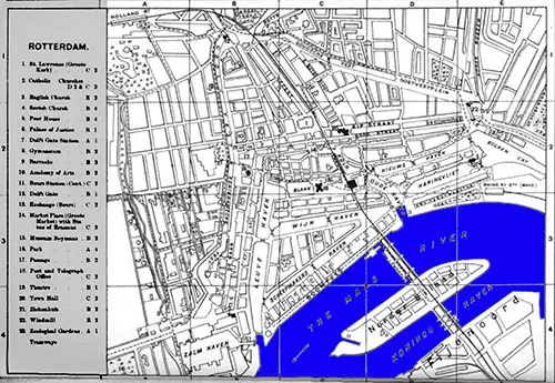
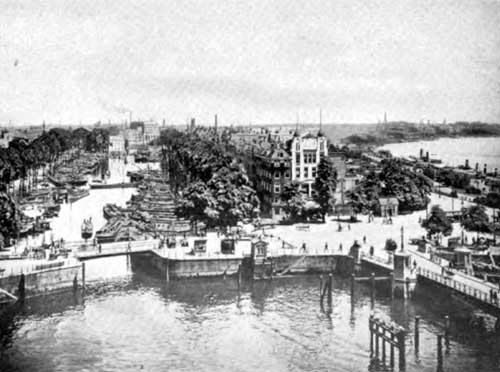
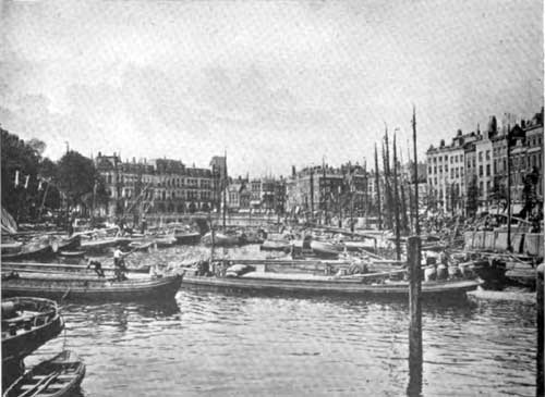
Rotterdam Harbour, 1901
The Port of Rotterdam (1909)
The Port of Rotterdam, although comparatively young is one of the most interesting and progressive of the Continental Ports; a keen rival of Antwerp for third place in the mad race for the commercial supremacy of Central Europe.
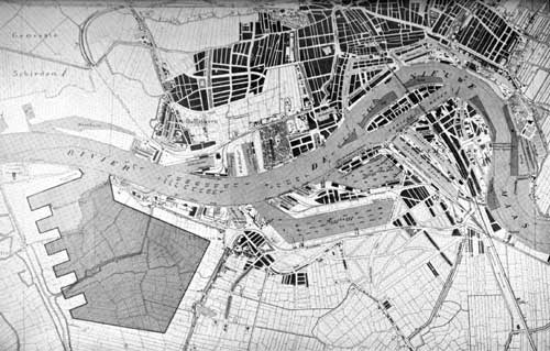
Plan of the Port of Rotterdam. New "Waal" Harbor area 800 acres, now being built is shown in cross-sectioned area in lower left-hand corner.
This port has been developed largely during the last half century. It is wholly a municipal undertaking, and no State or Provincial aid has been asked or received in the construction of its great system of quays and harbors.
Rotterdam occupies a most favorable location for the development of a modern port. It is situated on the northerly bank of the River Maas, the principal and natural outlet of the great Rhine District.
Previous to 1863, navigation between Rotterdam and the sea, a distance of about 18 miles, was most difficult, frequently taking steamers several days to make the journey. This was largely due to the shallowness and irregularity of the channel, but even then, with boats drawing but 10 feet of water the voyage was made during flood tides with no great difficulty.
With the development of larger vessels, however, Rotterdam at once realized that unless provision was made for a straighter, wider and deeper channel to the sea, her growth and standing as a port would be greatly handicapped. A new channel was then decided upon and built from Vlaardingen to the North Sea, a distance of 14 miles piercing the Hook of Holland.
This channel was completed in 1896 at a cost of $9,000,000. The City of Rotterdam paid about 10 per cent. of the cost and the Government the balance. The depth of water in the new channel is 27 feet at low, and between 32 and 33 at high tides, so that the largest sea-going vessels can now make the trip from the North Sea to Rotterdam in about 2 hours, where it formerly took several days.
Ocean-going Vessels Loading and Unloading in Midstream.
Rotterdam is especially fortunate that the range in the tide levels (about 15 feet) was not enough to require the construction of locks and gates in the new channel. With them the passage of the present 60 or more sea-going vessels in and out at the Hook daily, would have been greatly hampered.
The Government controls the river through an agreement between the adjacent states, and no dues can be levied against vessels moored in the river and not touching at the quays or harbors. Below the Williams Bridge, 62 buoys, accommodating 32 sea-going ships at the same time, have been provided, the distances between the buoys varying from 180 to 420 feet, and the depth of river at the buoys from 20 to 28 feet.
The new Meuse River passing through Rotterdam forms one large basin with the harbors constructed on either side. Starting from the easterly part of the town and working toward the North Sea, the location, size and use of the quays and harbors as given by Consul-General Soren Listoe, is as follows:
| Quay | Length (In Feet) |
|---|---|
| Maas Station Quay | 1,600 |
| East Quay | 1,200 |
| Boomjes | 3,150 |
| Willemskade | 1,730 |
| Westerkade | 1,200 |
| Parkkade | 1,700 |
| Quay between Park Harbor and Saint Job Harbor | 550 |
| Lloyd Quay | 1,800 |
At the latter quays the depth of water is 28 feet, while at the former six, the depth varies from 17 to 23 feet.
| Harbour | Length (In Feet) | Width (In Feet) |
|---|---|---|
| Boerengat | 3,850 | 120 |
| New Haven | 1,650 | 130 |
| Haringvliet | 1,350 | 200 |
| Old Haven | 900 | 240 |
| Kolk | 400 | 120 |
| Steiger | 950 | 50 |
| Groenedaal | 1,700 | 50 |
| Blaak | 450 | 180 |
| Wynhaven | 2,000 | 150 |
| Scheepmakershaven | 2,650 | 150 |
| Leuvehaven | 2,900 | 220 |
| Zalmhaven | 1,000 | 400 |
These harbors have a depth; varying from 5 to 12 feet and are chiefly used by the numerous market and inland craft; especially on Sunday, Monday and Tuesday of every week these harbors are overcrowded with the former type of Dutch vessels. As most of the connecting bridges are movable, all of these harbors can be reached by vessels without lowering their masts.
- Kleine Veerhaven 200 feet long, 80 feet wide.
- Veerhaven, 650 feet long, 240 feet wide, depth 17 feet at low water.
- Park Harbor 1,500 feet x 26 feet.
- St. Jobs Harbor 1,200 feet x 330 feet x 28 feet.
- Schie Harbor, 1,850 feet x 400 feet x 28 feet.
The three last named harbors are used principally for berths of the regular trade lines to different parts of the world.
The mouth of the river Schie leads into:
- Middenkous: 1'700 ft. x 220 ft. x 20 ft
- Voorhaven: 1300 ft. x 120 ft. x 10 ft.
- Achterhaven: 950 ft. x 170 ft x 16 ft.
- Buizenwaal: 350 ft. x 260 ft. x 7 ft.
These last five harbors are situated at the ancient town of Delfhaven, since 1885 annexed to Rotterdam, and generally used for vessels temporarily laid up.
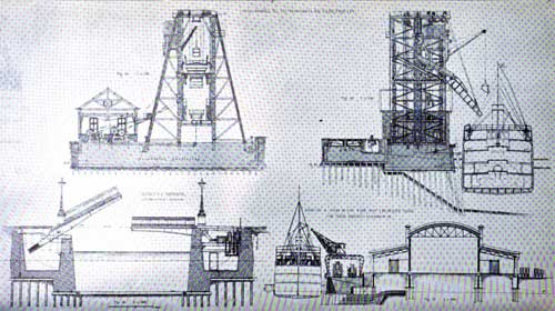
The Port of Rotterdam showing Electrical coal hoist, Bascule Bridge, and cross-section of sheds on the southwest side of the Rhine Harbor
QUAYS ALONG THE NOORDER EILAND
- Maas Quay, east side 1,900 feet long, 10 feet deep, for steamers going up the river and to the interior places of Holland, towards the east.
- Maas Quay, west side, 2,000 feet long, 10 feet deep, for steamers going down the river and to the interior towards the west.
- Prins Hendrik Quay, East Side, 1'700 ft. x 18 ft.
- Prins Hendrik Quay, West Side, 2'700 ft. x 20 ft.
The latter two accommodating passenger and freight steamers to Belgium and Germany, and also large Rhine craft and small sea-going vessels.
QUAYS ALONG THE LEFT BANK OF THE RIVER.
- Feyenoord Quay 1,000 feet long and 12 feet deep facilitates the approach of Rhine craft which usually lie anchored in the river in front of this quay.
- Nassau Quay 2,050 feet in length by 20 feet depth used by regular service up the Rhine and by small sea-going vessels.
- Stieltjes Quay, East side '700 feet long by 20 feet deep.
- Stieltjes Quay, West side 400 feet long by 21 feet deep.
- both berthing regular traders to England.
- Wilhelmina Quay 2,800 feet long by 28 feet deep where the HollandAmerican
line has its wharf.
Katendrecht Quay, 1400 ft. x 27 ft. deep- Charlois Quay, 670 ft. x 27 ft. deep
- St. Jan's Quay, 2800 ft. x 23 ft. deep
upon which are built the tanks of the different Petroleum Companies; this quay is not provided with walls, but wooden landing stages and the necessary duc d'alves facilitate the mooring of tank steamers
Mooring Pier in Rotterdam Harbour.
Kortennoord Quay 1,100 feet long by 25 feet deep wholly in the employ of the Royal Society for the Exploration of Petroleum Wells in tbe Dutch East Indies, which Company also has an oil refinery at this wharf.
HARBORS ON THE LEFT BANK OF THE RIVER MAAS
- Nassau Harbor 2,000 ft long, 260 ft wide & 15 ft deep.
- Persoons Harbor 1,900 ft long, 200 ft wide & 12 ft deep.
- Binnen Harbor 3,400 ft long, 260 ft wide & 24 ft deep.
- Entrepot Harbor 700 ft long, 200 ft wide & 22 ft deep.
This latter is a bonded warehouse harbor and its entrance from the Binnen Haven'is barred by a heavy log; in this harbor and along its quay dutiable merchandise may be handled free of tax.
Spoorweg Harbor 4,000 feet long x 400 feet wide and 25 feet deep. The freight department of the Netherlands State Railways is located here.
Rhine Harbor 29 feet deep and covering an area of 75 acres; its entrance is 500 feet wide and its width increases to 1,500 feet towards the end; it contains 19 mooring posts where 15 large ocean ships can be berthed and discharge their cargo on both sides into lighters and smaller vessels. The lineal quayage around this harbor is 7,000 feet.
Katendrecht Harbor 600 feet long, 350 feet wide, 23 feet deep.
Second Katendrecht Harbor 850 feet long, 450 feet wide, 27 feet deep.
Maas Harbor 1,100 feet wide, covering an area of 150 acres; depth 28 feet with 25 mooring posts accommodating 22 large sea-going steamers.
This harbor is thus far not provided with quays, but is protected by stone slopes constllucted upon wicker foundations which will permit the construction of quays when the necessity becomes apparent.
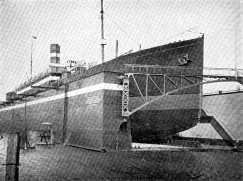
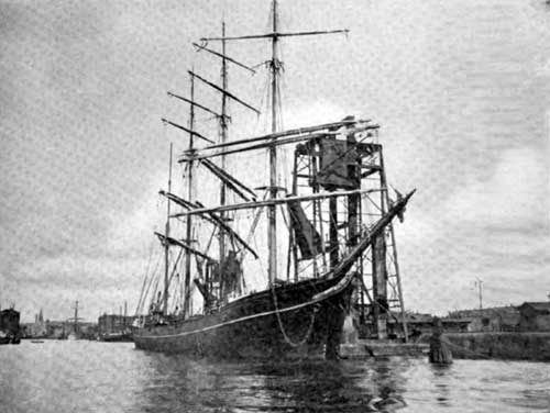
View of Ryndam of the Holland-American Line in Floating Dry Dock.
View of Ryndam of the Holland-American Line in Floating Dry Dock.
Dock Harbor 1,100 feet long, 500 feet wide and 37 feet deep; as its name intimates, this harbor is occupied by the three smaller city dry docks.
- St Jan's Harbor 400 ft x 200 ft x 10 ft
- Petroleum Harbor 550 ft x 200 ft x 20 ft
- Kortenoord Harbor 1,100 ft x 240 ft x 25 ft
These latter three are all occupied by the different Petroleum Companies for their re-shipment of oil into the interior of Holland and Germany.
Waal Harbor. This is the basin which is now in course of construction, and when finished will cover an area of eight hundred acres; thus far about 65 acres have been dredged out, but the work is steadily progressing, and it is confidently expected that this harbor will be completed and placed at the disposal of shipping in the course of next year."
To show how difficulties are overcome in the determination of the Rotterdam officials to develop one of the foremost ports of the world, it is worthy of note that in the construction ol the Maas Harbour it was necessary to demolish a church, a school-house, and 700 homes. The
area of this harbor is 150 acres. It was commenced in 1897 and completed in 1905.
The present area of the Rotterdam harbors, exclusive of the River and Konings Harbor, which together form one large basin, is about 500 acres, and the length of walled quays, 20 miles, and of those not walled, 7 miles.
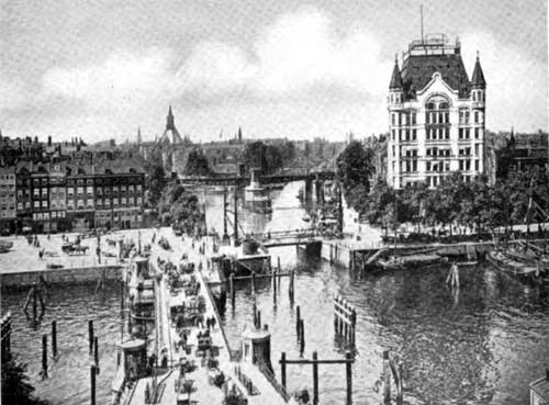
View in Heart of Rotterdam Showing several bridges, building on right "White House" the only skyscraper in city.
The construction of the Waal Harbor, now underway, well illustrates the confidence the people of Rotterdam have in the future of their port. Its area, 800 acres, is over five times the size of the Maas Harbor, the last one built, and almost twice as large as the present total harbor area
()f the city which has taken about a half-century to complete.
While the quays on the northerly side of the river have but two old style cranes, the new quays and harbors on the opposite side of the river are completely equipped with every conceivable mechanical device j fixed and movable electric, steam, and hydraulic cranes of varying lifting power, and fioating cranes, derrick cranes, grain elevators, coal hoisting apparatus, etc.
The Rotterdam port is poorly supplied with warehouse facilities, there being but one on the water's edge. This is perhaps largely due to the old prevailing custom of storing goods in the lower part of the merchant's private houses which are especially built for this purpose.
These are the four kinds of bonded warehouses in Rotterdam, subdivided according to the control exercised by the custom-house authorities:
- The Free Bonded Warehouse.
- Private Bonded Warehouses.
- Fictitious Bonded Warehouses.
- Warehouses, not controlled by the custom-house authorities.
The free bonded warehouse is an institution managed for the account of the municipality under the supervision of a Board of Control, some members of which are appointed by the Queen. The custom-house authorities keep constant watch over these bonded warehouses. The free bonded warehouse has two establishments, and the custom-house authorities superintend the carrying of dutiable goods to these bonded warehouses. The duties need only be paid when the goods leave these establishments.
Birdseye View of Shipping Activities in Rotterdam.
The private free bonded warehouses are intended for goods liable to a high excise duty, such as spirits, wine, etc. These warehouses are in private hands but are entirely under the control of the customs, so that they must be built in accordance with their regulations, and nothing can be either stored or cleared without their co-operation.
The fictitious bonded warehouses are for goods. liable to low duties, such as petroleum, cottonseed, tobacco, mineral waters, etc. The custombouse authorities confine themselves to controlling the quantities stored from time to time. These warehouses, therefore, possess the same advantages as the other kinds without their drawbacks as regards continual supervision.
Warehouses not controlled by the custom-house authorities, therefore contain either goods that come in free, or goods the duties on which have been paid.
The Harbor of Rotterdam is provided with seven fire fioats which are ready at a moment's notice during the daytime, and two of the steam floats are always patrolling the harbors at night for the extinguishment of fires.
The policing of the harbors is in charge of a special division of the municipal police force, consisting of one inspector, two deputy inspectors, and thirteen constables.
They are provided with a fast electric patrol boat equipped with a powerful searchlight. This force is a powerful agency for the maintenance of order and the prevention of theft and crime in the harbor.
A force of mounted men regulates traffic and preserves order on the quays and bridges. Because of the numerous canals, basins and harbors right in the heart of the city, many bridges are necessary, and all have to be of the movable type to permit of the passage of vessels.
These bridges are usually considerably narrower than the adjacent highways, and vehicular traffic becomes greatly congested if the bridges are open for any length of time.
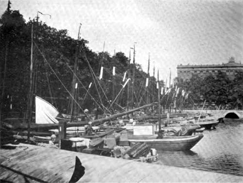
The tops of the quay walls. of the smaller harbors in the heart of the city are usually about four feet above the water level, and a row of Rhine boats lined up at one of these quays, with the sale and trading of farm and dairying produce by people from the interior towns of Holland,
presents a most interesting sight.
These quays are usually surrounded by tree-lined city streets, and the harbors are as much a part of the city growth and development as the streets are to American cities.
Rotterdam is probably better supplied with tug"boats than almost any other European port, there being no less than 350 owned by various local firm!.
The following table showing the number of inward-bound vessels. cleared in at Rotterdam, as compared with other ports in the Kingdom, since 1850, well illustrates the rapid growth of the port:
| Year | For the entire Kingdom | For Rotterdam | Percentage of Ships For Rotterdam | |||
|---|---|---|---|---|---|---|
| No. of Vessels | Tonnage in net. Reg. tons. | No. of Vessels | Tonnage in net. Reg. tons. | No. of Vessels | Tonnage | |
| 1850 | 6961 | 967,710 | 1940 | 346,186 | 27.9 | 35.5 |
| 1860 | 8217 | 1,591,419 | 2449 | 673,839 | 29.8 | 42.4 |
| 1870 | 8351 | 2,037,491 | 2973 | 1,026,348 | 35.6 | 50.1 |
| 1880 | 8164 | 3,438,038 | 3456 | 1,681,650 | 42.3 | 48.9 |
| 1890 | 9475 | 5,446,158 | 4535 | 2,918,425 | 48.2 | 53.6 |
| 1900 | 12307 | 9,450,710 | 7268 | 6,326,901 | 59.0 | 64.9 |
| 1907 | 14404 | 13,791,464 | 9221 | 10,107,155 | 64.0 | 73.3 |
The increasing importance of Rotterdam as the principal port of the rich Rhine Valley is shown by the following table giving the traffic up the Rhine from Amsterdam, Rotterdam and Belgium, during the last fifteen years, in metric tons:
| Year | Amsterdam | Rotterdam | Belgium | |||
|---|---|---|---|---|---|---|
| Tons | Increase | Tons | Increase | Tons | Increase | |
| 1890 | 170,365 | 2,582,791 | 1,165,457 | |||
| 1895 | 242,315 | 3,980,127 | 1,571,765 | |||
| 1900 | 446,837 | 7,845,544 | 2,604,632 | |||
| 1901 | 435,838 | 7,735,307 | 2,757,330 | |||
| 1902 | 451,936 | 8,197,989 | 3,238,843 | |||
| 1:3.51 | 1 :5.71 | 1:4.23 | ||||
| 1903 | 437,730 | 10,338,291 | 3,78&,569 | |||
| 1904 | 428,859 | 10,684,261 | 4,104,306 | |||
| 1905 | 478,920 | 12,771,307 | 4,435,580 | |||
| 1906 | 538,945 | 13,357,575 | 4,821,229 | |||
| 1907 | 597,518 | 14,762,226 | 4,937,737 | |||
Over 80 per cent. of the traffic down the Rhine is diverted to Rotterdam.
Rotterdam has a total of about 100 regular lines of steamers departing for various parts of the world on regular sailing days. The principal one of these is the well-known Holland-American line with its large fleet of passenger and freight steamers. Every week steamers of this line
leave Rotterdam and New York.
While no unusual difficulty is encountered in maintaining the requisite depth in the channel and harbors, Rotterdam maintains a fleet of dredges which are usually busy on maintenance or new work and in keeping the channels free from ice during the winter season. The material dredged is mostly used for filling and raising low ground, some of it being pressed through pipes by sand suckers, nearly two miles.
Owing to the treacherous mud and sand sub-soil in and around Rotterdam, much difficulty has been experienced in building permanent and durable quays, and many failures have been recorded during the last halfcentury.
The growth of the city of Rotterdam has been as phenomenal as that of its port. Since 1850 it has grown from a comparatively small city of 90,000 people, to over 400,000 in 1908.
The increase in the population of the five largest Dutch Communes in 1900 and 1907, is as follows:
| Community | Population | ||
|---|---|---|---|
| January 1, 1900 | January 1, 1907 | Percent Increase | |
| Amsterdam | 510,853 | 564,186 | 10.4% |
| Rotterdam | 318,507 | 390,364 | 25.7% |
| The Hague | 206,022 | 248,995 | 20.8% |
| Utrecht | 102,086 | 114,692 | 12.3% |
| Groningen | 66,537 | 73,278 | 10. % |
Between 1850 and 1907 Rotterdam's percentage share in the increase in the population for the whole country (The Netherlands) has grown from 6.4 to 14.0 per cent. and the percentage of the population of Rotterdam to that of the whole country has increased from 3.2 to 6.9 per cent.
To show how water transportation dominates the situation, it is said that the railroads handle but ten and the rivers and canals 90 percent of the commerce at Rotterdam.
Since 1870 the City of Rotterdam alone has spent over $20,000,000 upon her harbor system, and $9,000,000 upon the new ship canal to the North Sea, making a total investment of about $30,000,000.
The harbor system of Rotterdam is under the control of the "Municipal Board of Works"; a select committee of six Common Council men. with an Alderman as Chairman. The principal adviser of this Board is the "Director of the Municipal Works", who has as a permanent official staff, a deputy-director, two assistant managers, three engineerarchitects, thirteen chief-surveyors, fourteen surveyors and architectural designers, and a temporary staff of five engineers, one architect, three chief-surveyors, and two hundred and thirty surveyors, designers, assistant-surveyors, and foremen. Under this staff there are regularly employed about 1,550 laborers. This department is managed no differently from the other municipal departments, for the Director of the MunicipalWorks, in addition to his duties in connection with the great dock system, has charge of the water, gas, and electrical works, the municipal telephone, and the abattoir.
Interesting View in Rotterdam Harbour.
Interesting View in Heart of Rotterdam.
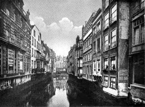
The Canals in Rotterdam Serve the dwellings as much as the city streets.
Interesting View in the Heart of Rotterdam.
Bibliography
"Port of Rotterdam: Unique Nautical Museum and Library" in Shipping: Marine Transportation, Construction, Equipment and Supplies, New York: Shipping Publishing Co, Volume 15, No. 2, January 25, 1922 p. 47.
A. E. Cooper Newham and Clifford Atkinson (Comp. & Arranged), "The Port of Rotterdam," in Shipping, Marine Transportation, Construction, Equipment, and Supplies, Vol. XIII, No. 7, Port of Rotterdam Number, 10 April 1921, Special Supplement.
Presbrey, Frank, "Approach to Rotterdam," in Presbrey's Information Guide for Transatlantic Travelers, Seventh Edition, New York: Frank Presbrey Co., 1911: P. 46-47.
Frederick L. Ford, "The Port of Rotterdam." In Part II: A Study of Some Representative European Ports in the Summer of 1909, Report of Connecticut Rivers and Harbors Commission to the General Assembly, Hartford: State of Connecticut, 1911, P. 53-60