Port of Gibraltar
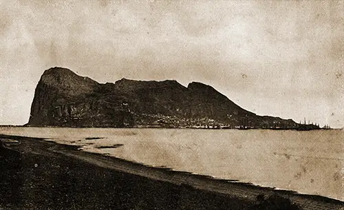
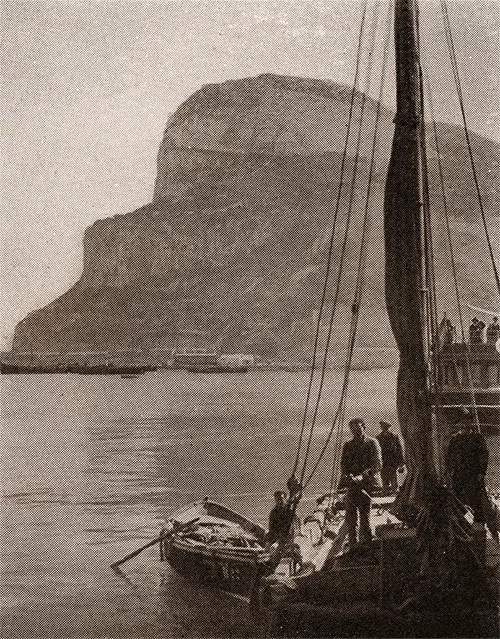
The Port of Gibraltar circa 1905. GGA Image ID # 143f8d2ca8
Approach to Gibraltar (1911)
Nearing the Strait of Gibraltar, the vessel crossing the Atlantic first sights the bold cliff shores of Cape St. Vincent in the southwest corner of Portugal. Lighthouse and signal stations here are plainly seen. Some hours later the coast of Seville is reached, and the way lies along Spanish shores with martello towers, the old signal stations of the Moors, crowning every headland. Cadiz is sighted, a white town at the water’s edge. Cape Trafalgar is passed later, and after this, the town of Tarifa.
Across the mouth of the strait, the African coast now comes in sight with the bare rocky range of the Jebel Kebir running out to Cape Spartel, the northwestern point of Africa. The Spartel lighthouse on the extremity was erected at the cost of the Sultan of Morocco, and is maintained by the commercial nations of the world, the United States bearing its part of the expense of keeping this light burning at the entrance of the great sea highway.
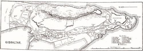
Map of Gibraltar. Cunard Line Handbook, 1905. GGA Image ID # 1fbdf12a28
The town of Tangier is conspicuous farther along the coast of the strait, a white drift about its harbor and up the rocky hills beyond. Some miles farther the Jebel Musa, the mountain of the Apes and the African Pillar of Hercules, rises opposite its mating pillar in Europe. Ceuta, a Spanish possession on the African shore, and the place of noted Spanish prisons, occupies the peninsula of Mt. Acho, marking on the south the eastern end of the strait.
The shores on the north of the Strait of Gibraltar are in striking contrast with the rocky and sterile heights of the African shores. The hills of the Spanish coast show green and gently sloping with green mountain ranges in the background. The Rock of Gibraltar is seen above the Spanish shores on the west of the Bay of Gibraltar, and as the last point of this is rounded, the Rock looms in sight across the Bay. On the west side of the Bay the Spanish town of Algeciras is seen.
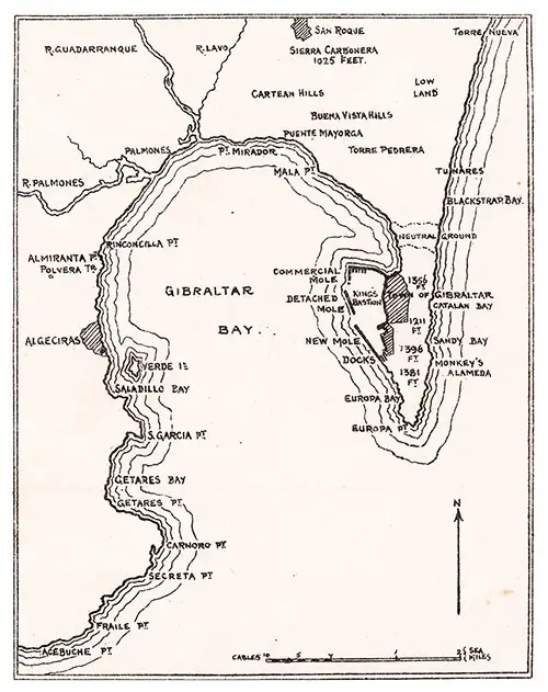
Map of Gibraltar Bay. Cunard Line Handbook, 1905. GGA Image ID # 1fbe1ac645
The approach to Gibraltar from the Mediterranean is along the Spanish coast of Almeria, Grenada and Malaga. Cape de Grata or Point de Elena, on either side of Aimer Bay, makes the first land sighted. The mountains of the Sierra Nevada range fill in the background, with high rolling land down to the precipitous shores that are a marked feature of these shores of Spain. Gibraltar as seen from the Mediterranean lies out in its full length of rock peninsula in strong contrast to the low lands about it.
THE SPECIAL TENDER AT GIBRALTAR (1905)
A special tender of the North German Lloyd is in service in landing passengers from their steamers at Gibraltar.
Formerly passengers landing and embarking at Gibraltar were obliged to avail themselves of small steam-launches or rowboats, and the introduction of a special tender for passengers has contributed very materially to the greater comfort and safety of passengers at Gibraltar.
The small tender, which bears the name Grille, is built of wood, and with special reference to the local requirements at Gibraltar. Her length is 79 feet 8 inches; beam, 18 feet; and depth, 9 feet 10 inches.
A handsomely appointed cabin furnishes ample accommodation for passengers in bad weather.
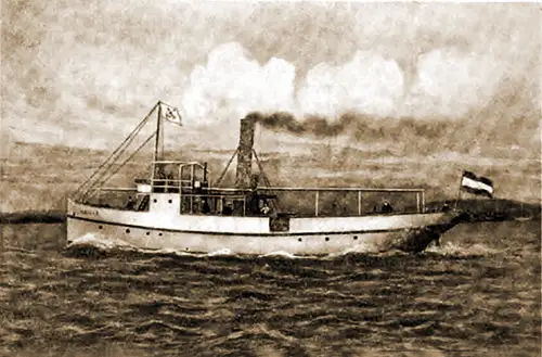
The Special North German Lloyd Tender Grille used for Landing Passengers at Gibraltar. GGA Image ID # 145552c8bc
Her construction is very strong. The vessel has been fitted with all conveniences. The extensive deck is provided with benches at the railing, and its whole length covered with an awning. Amidships there are two deckhouses connected by a platform, from which passengers disembark and embark from the transatlantic steamer.
As protection against the rain a pleasant saloon is provided under deck, aft. The motive power consists in a compound engine of about 150 horsepower, giving a speed of about ten knots. Fare : One shilling each way.
The New Special Tender at Gibraltar (1900)
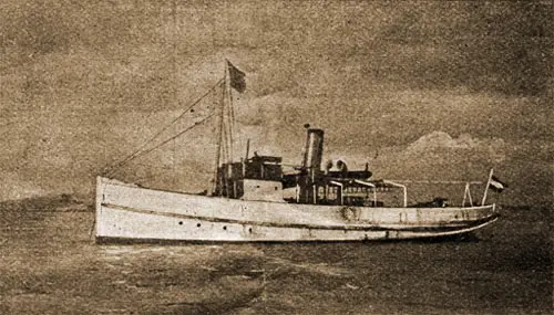
The Special North German Lloyd Tender "Undine" Upon Which Passengers Are Landed at the Port of Gibraltar. GGA Image ID # 1fbea572e6
A special tender has been built by the North German Lloyd for service in landing passengers from their steamers at Gibraltar. So far passengers landing and embarking at Gibraltar have been obliged to avail themselves of small steam-launches or rowboats, and the introduction of a special tender for passengers will contribute very materially to the greater comfort and safety of passengers at Gibraltar.
The small tender, which bears the name Undine, has been built of wood and with special reference to the local requirements at Gibraltar. Its length is 79 feet 8 inches; beam, 18 feet; and depth, 9 feet 10 inches.
A handsomely appointed cabin furnishes ample accommodation for passengers in bad weather. Its construction is a very strong o»e, and the vessel has been fitted with all conveniences.
The extensive deck is provided with benches at the railing, and its whole length covered with an awning. Amidships there are two deckhouses connected by a platform from which passengers disembark and embark from the transatlantic steamer.
As protection against the rain a pleasant saloon is provided under deck aft. The motive power consists in a compound engine of about 150 horse-power, giving a speed of about ten knots.
Between Europe and the Dark Continent, Gibraltar Is the Impregnable Pillars of Hercules of Classic Lore. It Is a Vivid Port, Thronged by Many Intermingled Races. The Samaria Has Reached Gibraltar in Eight Days. Going Abroad, 1923. GGA Image ID # 1bc648955e
GIBRALTAR (1925)
Anyone wishing to go from the Atlantic to the countries bordering the Mediterranean must pass through the Strait of Gibraltar. As one steams through this narrow passage between Spain and Africa, one can see on one side the bare hills of Spain and on the other side the high snowcapped hills of Africa. At the eastern end of this passage, the Rock of Gibraltar, the "Key to the Mediterranean," rises like a gray, crouching lion.
Seen from the deck of a steamer, Gibraltar looks like an island, but it is not. Many hundreds of years ago, a strip of water separated Gibraltar from the mainland.
As the ocean currents washed the shores, they deposited sand in this channel between the Spanish coast and the Rock of Gibraltar. Finally, a sandbar was built, joining the great rock to the mainland. Gibraltar belongs to Great Britain, but the central portion of the sandbar is neutral territory belonging to neither Spain nor Great Britain.
The Rock of Gibraltar is made of gray limestone. On the north and east, it rises almost straight up to 1400 feet. Only on the west and southwest sides can one climb to the top. Let us go to the top. To the north, one can see the narrow strip of sandy soil, in the center of which is a sandy waste.
To the north of this neutral wasteland, one sees a row of sentry boxes and Spanish soldiers walking back and forth. Beyond the sentries are the gardens of La Linea, where the vegetables and fruit for the town of Gibraltar are raised and where the peddlers and laborers who work in Gibraltar live.
To the south of the neutral territory is a large racetrack and other amusement places for the English army and navy men stationed at Gibraltar. To the west across the bay can be seen the Spanish town of Algeciras, surrounded by high hills.
Huddled below at the foot of the rock and clinging to its western side is the English town of Gibraltar. In the bay, one can see the ships of almost all nations of the earth going or coming. But what is that we see to the south? No, it is not clouds, but the smoky, blue hills of Africa, for Africa is only fourteen miles away.
The land around Gibraltar is so near Africa that it has been called the bridge between Africa and Europe. This is the bridge over which the Moors entered Portugal and Spain.
One of these Moorish conquerors, Tarik, built a castle on the rock of Gibraltar. He fortified it and called the place Jebel-al-Tarik (Hill of Tarik). This has been changed into the word Gibraltar. Part of the old Moorish fort can be seen today, built into the wall of the new British fort.
Gibraltar has always been considered the guardian of the Strait of Gibraltar. Because Gibraltar is the "Key to the Mediterranean," many nations have fought to possess it. No country ever held it very long until it was taken from Spain by Great Britain in the eighteenth century, and she has held it ever since.
The north, south, and west sides of Gibraltar are honeycombed with passages and galleries where guns are hidden. These passages were carved out of solid rock, and some are a half-mile long.
Walking through these tunnels, one finds holes or windows often covered by beautiful vines and flowers. Through these windows, one can see the blue Mediterranean, the ships steaming through the strait, and, on clear days, the mountains in Africa.
Gibraltar is one of Great Britain's most critical coaling stations. Thousands of ships leave England for Australia, New Zealand, and India. These boats carry manufactured goods and bring back raw materials to keep English faetones running. There must be other stations, such as Gibraltar, along these routes where coal can be obtained—many other ships also coal at Gibraltar.
In the town's streets, one sees fair-haired Norwegians jostling dark-haired Italians. There are Britishers bargaining with the Moorish peddlers. There are Greeks and Dutch, and many other nationalities constantly come and go.
There are boats of all sizes and kinds; some are tiny rowboats that carry passengers ashore, and others are great British battleships. Truly, Gibraltar is one of the busiest and most important spots on earth and maybe rightly called the "Key to the Mediterranean."
Vinnie B. Clark, Chapter VI. Romance Countries "Gilbraltar," in Europe: A Geographical Reader, New York-Newark-Boston-Chicago-San Francisco: Silver, Burdett and Company, 1925, pp. 269-271.
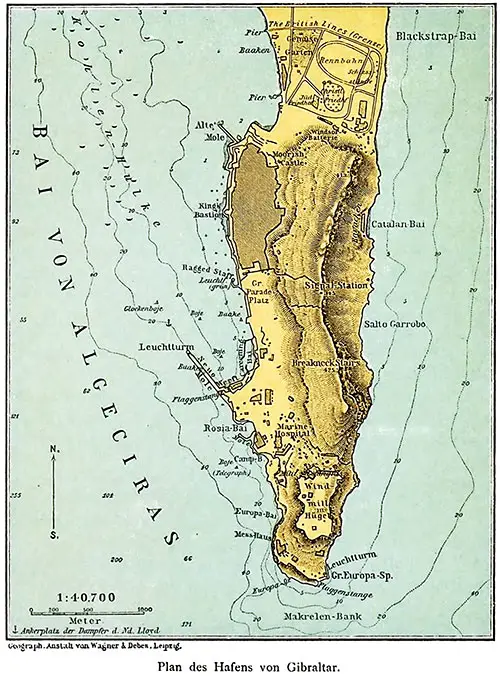
Map of the Port of Gilbraltar, 1892. Der Norddeutscher Lloyd, 1892. GGA Image ID # 216253793d. Click to View Larger Image.
Sailing Schedules
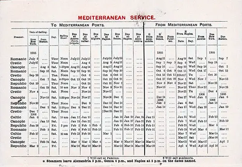
White Star Line Mediterranean Service from 6 July 1905 to 16 April 1906. Ships Include the Canopic, Celtic, Cretic, Republic, and Romanic. Ports Include New York, Boston, Azores, Gibraltar, Algiers, Naples, Genoa, and Alexandria. Will Call at Palermo and Almeria on some voyages. RMS Majestic Passenger List, 30 August 1905. GGA Image ID # 1dd4405a37. Click to View Larger Image.
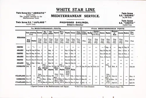
White Star Line Mediterranean Service Proposed Sailings from 29 August 1922 to 13 April 1923. Ships Included the Adriatic, Arabic, Cretic, and Lapland. Ports Included New York, Boston, Azores, Madeira, Gibraltar, Algiers, Monaco, Naples, Genoa, Alexandria, Haifa, Athens (Phaleron Bay), and Nice. RMS Majestic Passenger List, 6 September 1922. GGA Image ID # 1dd525881f. Click to View Larger Image.
Bibliography
Presbrey, Frank, "Approach to Gibraltar," in Presbrey's Information Guide for Transatlantic Travelers, Seventh Edition, New York: Frank Presbrey Co., 1911: P. 48-49.
"The Special Tender at Gibraltar," in North German Lloyd Bulletin, New York: Oelrichs & Co., Vol. XIX, No. 1, January 1905, p. 9.
"The New Special Tender at Gibraltar," in North German Lloyd Bulletin, New York, Oelrichs & Co., Vol. X, No. 2, August 1900, p. 7.

