
The Port of Antwerp
Antwerp harbor is unique, lying about fifty miles from the North Sea, on the right bank of the river Scheldt, at the crossing of the most important maritime route and the densest and most extensive net of rivers, canals and railroads.
Port of Antwerp: Growth of the Port (1922)
The Port of Antwerp, on the right hank of the river Scheldt, is situated at 88 Km. (about 54 miles) from the sea; vessels of the greatest tonnage are able to reach the quays, where they can come alongside without lightening. The town covers 2.620.74 Ha.; on 31at of December, 1912, it had a population of 322,275 Inhabitants, including the suburbs, these figures become 3.460 Ha., and 405.000 Inhabitants today.

Red Star Liner Gothland Entering Rovers Sluice, Antwerp circa 1921. GGA Image ID # 14557d942e
Among the numerous factories may be mentioned tanneries, malt floors, distilleries, sugar mills, and refineries, flour mills, coffee kitchens, biscuit, preserve, and cigar factories, soap houses, manufactories of candies, linoleum and oils, numerous diamond mills, brick works, cement works, telephone works, manufactories for engines, motor cars, boilers; shipbuilding, coopers’ shops, etc.
The Scheldt, which rises in France, becomes navigable before it reaches the Belgian frontier. Leaving Ghent are the last locks and dams: from that place downwards the river is called "Sea Scheldt” or "Nether Scheldt.” At Rupelmonde the Scheldt grows to be a deep, powerful river, having a width of more than 1,500 feet in front of Antwerp.
Near Doel, i. e., at a distance of more than ten miles from the sea, it gets the character of a bay. At Bath the river divides into two arms; the Eastern Scheldt, closed by the Dutch Government by means of embankments; the Western Scheldt, also known as "the Hont.” which is practically the only estuary. Navigation with Holland takes place by means of the Hansweert canal.
Since 1866 the Belgian Government has not raised any more navigation taxes.
Numerous canals and rivers and an extensive net of railways put Antwerp into connection with every part of Belgium and of central Europe. To these advantages must be added those of a quick and economic manipulation of the goods.

Sketch Map of Belgium Showing Provinces, Seacoast, Cities, Large Town, Railroads, and Highways. On the Bottom Left, Antwerp - The Gateway to Continental Europe in an Airline Diagram Showing its Relation to Principal Cities (Not Drawn to Scale). The SS Belgenland Into Europe, 1924. GGA Image ID # 11d55b4f2d
The port is composed of two entirely distinct parts:
- The river-port, bordered by quay walls with wide quays;
- Interior port, comprising locked basins, which are divided into marine and barge docks. The quays along the river Scheldt offer a mooring frontage of 5,500 running meters and the docks 16.500 meters; the railways both along the river quays and round the docks, total 156 km.
The immense installations principally comprise 12 maritime docks at the north, accessible by three maritime docks, three barge docks at the North, accessible by one maritime lock, a large landing stage up stream of the river quays, specially fitted for petroleum steamers; a basin with an outlet in the Campire Canal, and intended for interior shipping;
- 6 dry docks, 550,000 square meters of sheds,
- several warehouses and storehouses,
- powerful hydraulic and electrical stations,
- a shear of 120 tons,
- two 40-ton cranes,
- one 52-ton crane,
- one rolling 30-ton crane,
- one 10-ton crane, and
- one 5-ton crane,
- nearly 400 hydraulic as well aa electric cranes,
- an apparatus for shipping coals (coaltip) capable of lifting 25-ton trucks,
- one barge with two movable appliances for the transshipment of ores,
- 12 elevators for grain,
- 60 hydraulic of electric working capstans, etc.
In MM4 the maritime installations were completed by two maritime docks and by the prolongation of the maritime canal.
The dock walls at Antwerp with sheds and railways alongside, and anchorage for large steamers, provide a rapid means of transit trade on a modern system. Those walls were the first built on a large scale by means of compressed air.

The Landing Stage at Antwerp, Belgium. The SS Belgenland Into Europe, 1924. GGA Image ID # 11d5102358
Port of Antwerp - Progress of Overseas Traffic (1922)
ANTWERP, the most progressive port on the continent of Europe, is most advantageously situated, its geographical position being one of the leading factors in its abounding prosperity.
Abutting upon the most frequented maritime route of the world. It Is the best center of contact between the world's seaborne commerce and the greatest industrial and most densely populated areas of Europe.
It stands, like London, about 50 miles (88 kilometers) from the open sea and Is approached by the famous river Scheldt, which has a depth of from 36 to 39 feet at high tide in its shallowest parts. Before the war. 119 regular services of steamships operated from Antwerp.
While the Germans occupied the port no damage was done to either structures or equipment at the quays and docks, but the wharves were filled with immense stores of timber, sand, gravel and other war-material brought by river vessels from the Rhine.
The Antwerp port authorities in six months cleared this vast accumulation which had occupied 700,000 meters of wharf space and, by the middle of 1919, pre-war conditions had been re-established and work commenced or resumed on the new works to the north that are to double the capacity of the port within the next few years.
Today, Antwerp has not only achieved its pre-war efficiency and capacity as a port but has materially added to It in various advantages. As a proof of the saying that “Trade follows Facilities,'' the shipping and traffic records for the last year have shown progressive advancement month by month, indicating the return of the prewar level of activity, and this without the Immense trade with Germany that previously was transacted and in spite of the restrictions suffered by commerce generally as a result of war,
Antwerp, situated as it is, offers unrivalled advantages as a collecting and distributing center for every class and description of commerce. It is the best point of contact between the overseas traffic that there converges on the busiest maritime route in the world and the great industrial areas of Belgium and Northern France, the Rhine provinces, Czechoslovakia and the other new states of middle and Eastern Europe with their Immense industrial possibilities and ever-increasing demands for necessities produced in other countries.

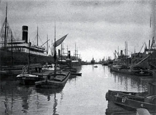
A View of Antwerp Harbor. About Antwerp and the Red Star Line, 1904. GGA Image ID # 11d97ef69
Antwerp is plainly indicated as the center of this commercial activity, while the other great ports, Havre. Rotterdam and Hamburg may be described as the extremes of that activity.
The valleys of the Scheldt, the Lys, the Meuse and the Rhine, all converge towards Antwerp, the center of a magnificent network of European railroads, the ramifications of which lead to Switzerland. Italy. France, the New States of Central Europe and the Balkans, to Constantinople and the shores of the Black Sea.
Numerous regular lines of steamers, moreover, follow the coast of Europe all around the continent, from the North of Norway down to Asia Minor while other great steamship lines connect Antwerp, direct with all the ports in the world.

View of Antwerp Harbor. The SS Belgenland Into Europe, 1924. GGA Image ID # 11d524eb2a
Antwerp's Pre-War and Future Status as a Major Port (1919)
IN the coming reorganization of European ocean transportation Antwerp Is bound to play a very important role. Before the war, It was one of the most prominent of European ports and a close rival of Hamburg. During the year 1912, 13,761,000 tons of shipping entered the Port of Antwerp or only 36,000 tons less than put Into Hamburg.
In the case of London, Liverpool and Rotterdam, the corresponding figures were 12,989,000, 11,810,000 and 12,179,000 tons, respectively.
While a Belgian port, Antwerp's prosperity is only to a moderate extent dependent on that of Belgium. Were the great traffic of the hinterland of Central Europe, and especially of Germany, which passes through the port, taken away, its whole economic structure would be destroyed. In fact, it was due almost entirely to English and German shipping enterprise that Antwerp reached its prewar Importance as an entrance door to Europe.
In the year 1912, the port was entered by 3,394 English and by 1,627 German ships, with a respective tonnage of 6,269,438 and 4,149,157 tons. More than 70 percent of the total shipping making use of Antwerp was therefore either of German or of British origin.
It was a well-known fact that those two chief frequenters of the port were engaged in a bitter rivalry for the possession of the most desirable landing stages.
Indeed, all through the year 1913, diplomatic exchanges had taken place between the governments of Belgium, Great Britain and Germany, with a view of settling some of the rival claims made by several of the large shipping companies of the contending parties.
In order to understand the Ins and outs of this rivalry, it would be necessary to examine more closely the relations between Antwerp and its hinterland.
The city lies on one of the arms of the ScheIdt and Is well connected by a number of inland canals and railroads with the principal Industrial centers of Belgium, Luxemburg and Germany. The port of Antwerp therefore affords access to a very important market, which furnishes both inward and outward freight in exceptionally large quantities.
Across the German border such rich Industrial cities as Aix-La-Chapelle, Cologne, Düsseldorf, Crefeld, Essen and even Dortmund are with In comparatively easy reach of Antwerp, and all these places have availed themselves to a very considerable extent of the port facilities of Belgium's shipping center.

The Steen Landing at Antwerp. About Antwerp and the Red Star Line, 1904. GGA Image ID # 11d99d3c0c
But there Is one serious drawback to this otherwise favorable position of Antwerp. This is the proximity of the Dutch port of Rotterdam. Viewed from a general standpoint, Rotterdam Is even better located as a port than Antwerp.
"It does not have to be approached through a foreign country, as is the case with Antwerp, where the coast is under the Dutch flag, and its Inland connections are even better than those of Antwerp.
Rotterdam is also easily reached from Germany via the Rhine, and there is a very active barge traffic between the German cities along the Rhine and Rotterdam.
German Trade Catered For
Before 1914, the competition of Rotterdam was seriously felt by Antwerp, and the Belgian Government had taken steps to facilitate the transportation of German commodities and goods destined for Germany.
This wish to please Germany exerted considerable influence on German-Belgian commercial relations before the war and found expression also in the stipulations of the German-Belgian commercial treaty, which provided especially for the existence of this transit traffic.
But the Belgian Government had even gone a step further and had arranged special rates on the Belgian railroads for German goods bound for overseas.
Through these various means it had become possible to strengthen the economic position of Antwerp materially, so that before the war It had become not only one of the leading shipping centers of the world, but also one of the strongest factors In international distribution.
This side of Antwerp's development possesses considerable interest for our own shipping men, and may have a material effect on the future policy of American shipping enterprises.
Of the port's wheat imports, which amounted to 1,841,000 tons during the year 1912, 418,000 tons arrived from the United States and Canada, 644,000 tons were of Rumanian origin, British India sent 216,000 tons, and the La Plata states 397,000 tons. Barley came principally from Rumania and British India, and corn from Argentina and Rumania.

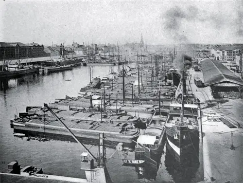
View of the Modern Seaport of Antwerp. About Antwerp and the Red Star Line, 1904. GGA Image ID # 11d9b330b7
Very little of the corn unloaded at Antwerp was imported from the United States. Brazilian coffee and American tobacco dominated their respective markets. Only a comparatively small part of the large traffic handled at the port was destined for Belgian consumers.
Much of the imported merchandise ultimately found its way either to England or Germany. The grain trade of the port was largely controlled by German interests, and great quantities of the grain imported were shipped every year to west and south Germany and to Switzerland, which latter country used Antwerp's port facilities to a very great extent.
German and English buyers also predominated at the famous Antwerp wool auctions, which were only second In Importance to those of London. What made the port attractive as a wool center was the close connection, which existed between it and the La Plata markets, which was almost entirely due to the great German lines to South America.
These made Antwerp their regular port of call, taking German Industrial products from the German Rhineland to South America and returning laden with wool and other South American commodities to Antwerp.
Even British shippers found it frequently to their advantage to employ the fast German steamers from Antwerp to South America, and several of the British shipping lines plying between London and Antwerp acted as freight feeders for the German South American steamers.
Exigencies of international distribution, which it could take too long to explain, made Antwerp play a rather secondary role in respect to the distribution of cotton, but the close connection between it and South America made It an excellent port for the distribution of textiles, a great quantity of which was shipped through Antwerp by English and German merchants.
Antwerp's Future in the Balance
The future of Antwerp Is now dependent on the action of the Peace Conference at Paris. There is a national and an international side to this problem of Antwerp, only the latter of which concerns us. Antwerp is now entirely free from German domination. The hope entertained by German expansionists that the port might come entirely under German control has disappeared with the victory of the Allies.

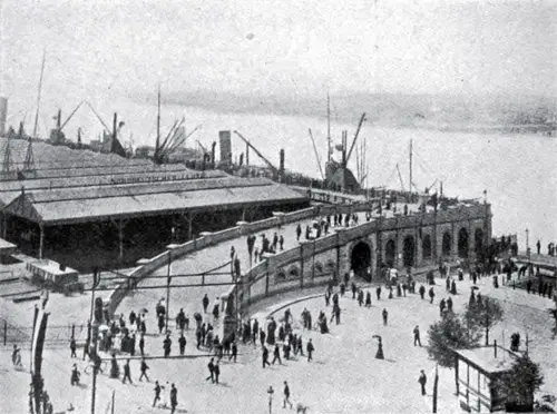
Entrance to the Great Docks at Antwerp. About Antwerp and the Red Star Line, 1904. GGA Image ID # 11d9bdae8c
This Victory, however, cannot do away with the economic factors affecting the business of the port. Just as In the past, Antwerp will continue to be dependent for most of its carrying business on the great territory back of It, In which are included the German Rhineland, South Germany and Luxemburg. If it is to retain this business, it will be necessary to strengthen this connection rather than to weaken it by interposing artificial barriers, cutting offGermany from access to the sea via Antwerp.
If such a step should be seriously attempted, the port would lose immediately a large part of its pre-war trade. In such a case, this would most likely be deflected to either Rotterdam or Amsterdam, or possibly even to one of the German ports on the North Sea. All this would certainly not be in the interest of Antwerp.
Ita barrier between Antwerp and Germany were to be erected, Antwerp's usefulness as an Import port would be seriously affected. In all probability, Germany would not object to receive foreign merchandise by way of Antwerp if It could not be obtained In any other way.
The Antwerp route, however, would be an extremely expensive one were relations to be one-sided, and were no return freight to be had for the canal and river barges. The inevitable outcome would be the diversion of all Import trade to the Dutch ports, where a large return freight could be obtained.
European economists have laid some stress on the possibility of exporting through Antwerp certain French Industrial products originating In Alsace-Lorraine. These would be shipped on Rhine barges downstream and then by canal to Antwerp.
This traffic, however, was not very large in the past and is not likely to grow very much hereafter. As far as Iron and potash are concerned and other raw materials, this route will probably be made use of. It would, however, seem to be too slow for the shipment of ordinary merchandise, which is much more efficiently carried by rail.
It would certainly be more In the Interest of France to ship the industrial products of her recovered provinces by rail to one of her own ports, and in this way to bestow the benefit of her former possessions on French Interests exclusively, a policy which also conforms with the practice usually followed by France In this respect.
There remains the eventuality of a possible separation of the present German Rhineland from Germany, a policy which is said to be strenuously opposed by our own President and also to find no approval In England.

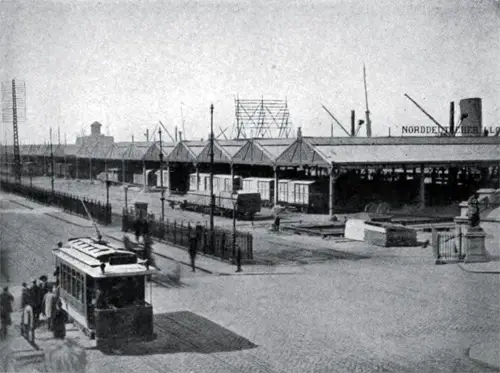
The Red Star Line Pier at Antwerp. About Antwerp and the Red Star Line, 1904. GGA Image ID # 11d9ef9ec8
Such a course would very probably result in attracting to Antwerp a great part of the export trade of that region, at least that part which would not find it more convenient to ship via the Dutch ports.
But It seems not to otter any sufficient guarantee tor a regular flow of Import shipments, as only a comparatively small part of the import shipments to Germany via Antwerp are destined for the Rhineland proper. It Is in Antwerp's commercial Interest, therefore, to have its former trade relation with Germany restored.
Antwerp's Importance For Our Shipping
American shipping would have cause to regret any outcome, which would deprive Antwerp of its great hinterland. Connected with its hinterland, it might become a very useful central port of call for our shipping, both for the purposes of our European trade as well as a basis for the organization of any system of transshipment routing, which we might inaugurate after the war.
The writer has pointed out already in former articles the desirability of American ships engaging In the Baltic trade. Our future trade connections with the new Poland and Russia will necessitate our taking such a step.
The chances are that there will be a preponderance of American freight going to Russia as compared with Russian freight moving in the direction of the United States.
This would necessitate the return of American ships from Russian ports with holds only partly filled, a situation which is not very desirable In the interest of economical operation.
In normal times, a very active trade between the Russian Baltic ports and Antwerp usually takes place. During 1912, for Instance, Russia shipped to Antwerp 41,000 tons of wheat, 13,000 tons of barley, 64,000 tons of oats, 48,000 tons of corn, considerable numbers of hides, bristles and much other Russian material, which in turn was transshipped at Antwerp to other destinations.

Panoramic View of the Port of Antwerp and the Red Star Line Docks. About Antwerp and the Red Star Line, 1904. GGA Image ID # 11da1e7c80
Our ships bringing merchandise to the Russian Baltic ports might engage in part in this trade between the Russian ports and Antwerp and other ports in the vicinity and might return to the United States after having embarked the commodities of the German Rhineland and of South Germany.
Assuming that Antwerp will regain Its former large South American trade, due almost entirely to Its close relationship with the German markets, the organization of a triangle shipping service between this country and Antwerp via South America would then become possible.
The importance of Antwerp as a market for the distribution of South American produce has been already enlarged upon. It is well known to American shipping men that our commerce with South America is very much hampered, and will continue to be so by the lack of return shipments from South American ports to our own.
The considerable divergence in tramp shipping rates between United States ports and South America, and most of the European ports and South American destinations is the direct result of this state of affairs.
With Antwerp forming part of our own international transportation system, a plan might be developed, working approximately as follows: Vessels could start from a United States port, laden with American Industrial products for a South American destination. After discharging their cargo, they could take on South American produce for Europe, which they could unload at Antwerp.
There freight might be taken aboard either for the United States or for any eastern destination, for which frequent cargoes are obtainable in that port. In the latter case, the ship would return from Eastern Asia with cargo for America, of which there is never any lack.
In this respect, Antwerp may otter even greater advantages to American shipping than any of the other leading ports of Europe. National Interests will largely govern the after-war port and shipping polices of the three leading European shipping countries, viz., England, France, and Germany.
While these may not actually discriminate against foreign shipping, there Is no doubt that Imperial preference In England and French particularism well strive to retain as much as possible of the national trade for the shipping Interests of their own countries.
Considerations of financial economy may also force the German exporters and merchants to make use as much as possible of such shipping as may be left to them.
On the other hand, Belgium is no seafaring country. Of the large shipping trade of Antwerp, only 921,000 tons were carried In Belgian bottoms. Only 602 Belgian ships entered the port in 1913, as against 3,352 English and 1,705 German ships.
Belgium, therefore, has no reason to favor Belgian shipping unduly is interests, in fact, lie rather in as large a development as possible of Its port as a port of call for the shipping of the world.
As German ships may not call as frequently In Antwerp as formerly, and as England will most likely commit its shipping in this direction, it has to be feared that Antwerp will lose in Importance.
It will, therefore, certainly welcome any move on the part of American shippers to assist In the future development of the port and to supplement not only the tonnage required for handling Its transit trade, but also to carry Belgian products to other markets, a service which, so far, has been principally performed by German Shipping.
The port of Antwerp may also soon have for us an additional interest by reason of the fact that it may become the most important emigration port of Europe. Before the war most of the European emigrant traffic was handled by way of Bremen, from which 239,000 emigrants embarked in 1913. Hamburg took second place with 192,000 emigrants, while Antwerp handled only 115,OOO.
The emigration business of Antwerp was mostly in the hands of the German shipping lines, which had an operation agreement with the Red Star Line. It is practically certain that the German shipping companies will not toke so extensive an interest again in this phase of the ocean-carrying business, and that their former emigrant traffic will fall to the shipping of other countries.
It would greatly help if the United States could thereafter look after emigration traffic bound for its shores, and for emigrants from the moment when they board a ship. In this respect, the port of Antwerp could prove very helpful.
Antwerp's Quick Revival After World War I (1919)
Belgium’s leading seaport, Antwerp, Is throwing off the paralyzing effects of the War with extraordinary rapidity, and the energy displayed by its civic and business rulers is of good omen for the future prosperity of this war-worn city.
Three months ago, anyone visiting It would have concluded that at least halt a year must elapse before its trading and shipping activities could possibly be resumed.
Everywhere the quays were in a state of sad neglect and desertion, littered with weeds, rubbish, and the giant heaps of gravel and stocks of wood prepared by the German Invaders for use in their trenches.
The people of the town were in no better case. Underfed, ill clothed, dispirited, they appeared to present a problem that might well baffle the efforts of the most determined. All this has now changed. The Inhabitants have been given a new lease of life, and are today almost themselves again.
Harbor of Antwerp, Belgium circa 1921
The clearance of the quays and docks Is proceeding rapidly. All the wood has been removed and transported to various places where It can be utilized. The wood left at the port is estimated at a value of two hundred million francs.
Vessels are arriving from overseas laden for the most part with food and manufactured articles, but the time has arrived, says an Antwerp journal, when some of the shipments might advantageously take the form of the raw materials of Industry, which the country awaits eagerly to enable It to take up Its normal Industrial life.
Towards that desideratum, the abolition of licenses for Importation should mean something: and, generally, it may be said that Antwerp is regaining Its old position as a great Continental seaport with surprising rapidity.
It aspires, indeed, to something more than merely to regain its pre-War eminence as a leading Continental entrepôt and trading center. For one thing, it is deeply concerned about its commercial "hinterland."
On the other hand, peaceful trading relations with what was once the German Empire will be extremely difficult, If not altogether Impossible, for years to come, considering all that has passed since 1914.
On the other hand, the reversion of Alsace-Lorraine to France makes these provinces subject to French Imposts, especially the Customs taxes Imposed by France upon goods imported Into the Republic via Antwerp.
Unless there is a substantial revision of these things, Antwerp may be left In the future with a more contracted "hinterland" than before. Obviously, the remedy is to be found In Belgian annexation of the Maastricht district and the absolute freedom of navigation on the ScheIdt.
Antwerp's Port in Good Shape (1919)
The Belgian Ministry of Shipping has cabled regarding the condition of the port of Antwerp that the extensive Rhine quay berths, where the Red Star liners used to lie and Which were blocked with lumber and all kinds of materials during the German occupation, have been all cleaned up and are ready for the proper discharging and loading of ocean steamships.
As the result of the energy and perseverance of the base, naval, and port authorities these quays are quite as useful today as they were in the prewar period.
There Is an excess of cranes over the actual number formerly In use, soundings show that there has been no excessive silting up along the quayside, and vessels of average draft lie safely afloat at all tides. The rails have been connected up and scores of rail wagons pass over the tracks dally loaded with goods from Incoming steamers.
There is plenty of labor to be had. The ScheIdt River pilots and other seasoned river men say the channel has suffered no appreciable damage through neglect, and at dead low water, there is twenty-one feet, with a tide variation of 14-16 feet, while most of the aids to navigation have been replaced and the fairway Is well buoyed.
Since the armistice, a total of 324 seagoing ships have entered Antwerp, representing In February a good percentage of the pre-war tonnage of the port. It Is Interesting to note the development of this traffic by months:
- December: 50 seagoing ships, 83,333 tons.
- January: 109 seagoing ships, 167,333tons.
- February: 162 seagoing ships, 124,251 tons and the early Indications are that March will see a further large Increase In this tonnage.
The Port of Antwerp's Past, Present and Future (1919)
In the course of Its long history, Antwerp has experienced many periods of prosperity and eras of severe depression. In the time of the Romans, the giant Antigone had built a castle on the present site of Antwerp. This tyrant demanded tribute from all ships which passed his castle.
If the captain was unable to pay the sum demanded, the giant would cut off his right hand and throw it In the ScheIdt River, according to legend. This led to the city being named Antwerpen, for in Flemish "ant" means hand and "werpen" means to throw.
Finally, the Romans, under the leadership of the brave Salvius Brabo stormed the giant's castle. Antigone’s head and right hand were cut off and thrown Into the ScheIdt. Already a flourishing trading place in the seventh century, Antwerp was destroyed by the Normans In 836. From the tenth century on Antwerp developed rapidly and soon became an Important seaport.
In the middle of the sixteenth century, It reached the height of Its prosperity, having become the seat of the East Indian trade. The deepening through natural causes of the Western branch of the ScheIdt helped greatly to its prosperity, as sea-going vessels were then enabled to proceed to .Antwerp direct Instead of having to take a roundabout course through the Scheldt's eastern arm.
In the "reign of Phillip the II of Spain, the prosperity of the city rapidly waned. Stormed by the Spaniards In 1685, its population of 85,000 fell off nearly one-half. Its commercial Importance passed with the signing of the Treaty of Westphalia, one of the articles of which closed the ScheIdt river to navigation.
It was not until 1792 that Antwerp experienced a new period of prosperity, when the City was incorporated into France and the Scheldt thereafter thrown open to all shipping. Upon Napoleon's downfall in 1816, the city's trade was hampered by the shipping dues levied by the Dutch.
Prior to 1850 when the navigation of the ScheIdt River was restricted, very little shipping arrived at the port of Antwerp. The city's rise as a Port dates from 1863, when the taxes Imposed by the Dutch 'on vessels bound for Antwerp were done away with by the payment of $9,000,000.
The following table shows the net registered tonnage of ships entering Antwerp for the various years named:
Years: Tonnage
- 1850: 239,000
- 1860: 564,000
- 1870: 1,363,000
- 1880: 3,064,000
- 1890: 4,606,000
- 1900: 6,720,000
- 1910: 12,654,000
In 1912 the net registered tonnage of all vell8els arriving and leaving from Belgian ports was 32,670,000 tons. of which 27,350,000 tons were credited to the port of Antwerp. In the same year, 659 sailing vessels and 13,410 steamers, aggregating 13,757,000 net tons entered Antwerp.
In 1913, 7,056 ships, aggregating 12,022,101 net tons, entered the port of Antwerp, as contrasted with 15,073 ships of 14,186,000 tons In the case of Hamburg. In the same year 11,448 ships of 18,915,648 net tons put in at the port of Rotterdam.
These statistics show that the vessels call1ng at Antwerp are of a much larger average size than those entering the ports of Hamburg and Rotterdam.
No less than 12,762,000 tons of merchandise were unloaded at Antwerp in 1912, while goods aggregating 10,169,000 tons were shipped therefrom. A large proportion of the goods discharged at or shipped from Antwerp represented goods bound for or In transit from Germany. Should Antwerp not be able to recover this transit trade hereafter, it is not likely to regain Its pre-war status as a port.
The port equipment of Antwerp was badly damaged by the Germans during their occupation, reports the Antwerp correspondent of "Lloyd's List." He states in a review of general conditions at that port:
"The port of Antwerp Is in a better state than was anticipated at first, navigation is possible, the fairways are open, and the passes have a depth of 27 feet at half -tide.
The Germans have been dredging some of the passes In order to allow the craft lying In the Antwerp docks and captured by the Belgian authorities In August 1914, to reach the Dutch ports. But though the river Is open to shipping, the quays along the river and in the docks are in a pitiable state.
They are full of all kinds of miscellaneous materlal-1.Z00,OOO tons of sand (for the trenches), 840,000 cubic meters of timber from Riga and other Russian ports, 10,0000 tons of coal, munitions, guns, etc. left by the Germans.
Before the loading and unloading of ships will be possible, this material will have to be shifted away. The timber is piled under the sheds (hangars) high up to the roofs.
''The sluices giving entrance to the docks are Intact, but the fairway of the new Royers sluice is full of mud and will require a good deal of dredging. The Germans left behind in the docks about 2,000 river barges, most of them loaded with different goods.
Some of the wooden river barges have sunk through lack of care. Except for the North German Lloyd steamer Gnelsenau and the Belgian steamer Anversolse, there Is not a single seagoing craft in the docks.
"There had been thirty-two German and Austrian vessels Interned in the docks since August, 1914. These have been sent to Dutch harbors; also a British and a French steamer.
Twelve torpedo boats took refuge in Antwerp after the abandonment of Zeebrugge; they have also left for Dutch ports. During the occupation the German contractors for building the new dry dock have continued work, and the dock will be ready for use at an early date. It will be a great Improvement for Antwerp, as the dry dock accommodation was Insufficient.
"The pre-war traffic of the harbor will not be re-established before another year. The first thing the Belgian authorities are caring for Is to replace the beacons and buoys in the ScheIdt, and at the same time to replace' the lights, in order to allow the traffic in the river by night.
This Is rendered difficult In the Dutch part of the ScheIdt, from Flushing to Bath (nearly thirty miles). as the Dutch authorities are to replace the buoys, beacons and Lights themselves and are generally not in a hurry to do it. They do not allow the Belgians to do the work. If there Is nothing to hamper the work navigation by night will be possible in two or three months.
"As can be easily inferred, the commercial activity of Antwerp Is nil at present. Many of the native business men have died since the war. The Ailed businessmen and a number of Belgians are away, and the Germans have gone. Some of the Germans remained In Antwerp until the closing days, including the North German Lloyd agent. They have gone now and will never come back.
"Every German and pro-German will be put aside. Already the work has been started. The Supervisor of Shipping and Commerce, who was a notorious pro-German. has been dismissed. The Cunard Line has obtained the best berth at the river quays-a berth, which was leased to the Norddeutscher Lloyd before the war.
The Antwerp authorities are firmly resolved to give to British, French, Belgian and other Ailed lines the berths on the river front where the German liners used to moor. British shipping people have a splendid future in Antwerp."
The Port of Antwerp. An overview of the Harbor and City (1913)
ANTWERP, famous as the birthplace of Quentin Massys and Rubens, is not only a town of art and archaeological treasures; it has also the qualities and attractions of a large modern city, and ranks among the greatest maritime ports of the world.
The harbor is unique, lying about fifty miles from the North Sea, on the right bank of the river Scheldt, at the crossing of the most important maritime route and the densest and most extensive net of rivers, canals and railroads. Thus it is the natural port of a most active population, as well as the most industrial part of Europe.
The Scheldt, which has its source in France, and is navigable before entering Belgium at Antwerp, is a majestic river about 550 yards wide, and from 11 (at low tide) to 15 (at high tide) yards deep.
A few miles farther down, the river has the aspect of an estuary. There a maritime canal connects the Scheldt with the Rhine, and in that way provides for the traffic between the Rhine provinces and Antwerp.
The valleys of the Scheldt, the Meuse, and the Rhine form the immediate " hinterland " or back-country of the Belgian port, but thanks to the numerous means of communication by rail and water, this back-country stretches uninterruptedly as far as France, Switzerland, Italy, Austria, Hungary, and even the Balkans.
The port of Antwerp consists of two distinct parts, the river and the docks.
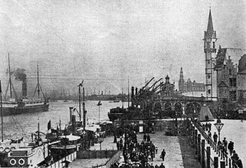
The right bank of the Scheldt has quay-walls over a length of nearly four miles, along which are laid out embankments from 110 to 265 yards wide, provided with sheds, cranes, railway lines, and skirted by a broad avenue for the traffic.
Alongside these quays lie the ships of the regular steamship lines, which have their fixed berths. Thanks to the great depth of the river, ships drawing up to 33 feet can moor directly at the quay-walls.
At the southern end of the river quays are the petroleum installations, extensive enough to store 3312 million imperial gallons of petrol, 3 million gallons of benzene, 9 million gallons of heavy oils, and 12 million pounds of resin.
Yet these installations, although covering an area of 12312 acres, are insufficient, and at present the necessary appropriations are being made by the municipality for extending them over an area of 175 acres.
There are 20 docks, 16 maritime and 4 barge docks. They cover a total area of 440 acres and offer a mooring length of about 15 miles. The water at these docks is from 7.2 to 12.4 yards deep.
Communication with the river Scheldt is had by means of three maritime locks, of which the Royers Lock is the most important, allowing the largest vessels to dock at any stage of the tide. This big lock can be filled and emptied in ten minutes.
Moreover there are 7 dry docks of various dimensions, the newest being 245 yards long, 27 wide, and 9.55 deep from the water-line. This immense dock can be emptied in two hours' time.
Generally the river quays and docks are bordered by three railway lines, while two other lines lie parallel to these, but along the inland side of the sheds. All these lines are connected to six stations, being themselves directly linked to the general railway lines. The harbor lines have a total length of 334 kilometers, yet they are being almost constantly increased.
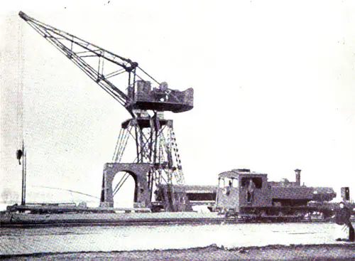
For loading and unloading the shippers utilize hundreds of hoisting machines of diverse power and description. There are, for instance, 300 hydraulic and more than 100 electric cranes of 2, or 2 1/2 tons lifting power each, one crane of 20 tons, one of 40, one of 50, and shear legs of 120 tons, a coal-tipping device, 5 floating cranes, and 17 pneumatic grain elevators, each of them capable of transshipping more than 150 tons of cereals an hour. Other powerful hoisting plants, among them a crane of 150 tons, are building for the port of Antwerp.
This equipment, which would seem abundant, and these immense installations, are in fact insufficient to answer the requirements of the ever-increasing traffic of the port of Antwerp.
Many projects of extension have therefore been elaborated, and several are being realized, among the latter, a great maritime lock, called "Kruissch ans," 6 miles downstream of the town; its lock-chamber will have a length of 300 yards and an opening of 40 yards, allowing ships drawing 42 feet to go in and out at any stage of the tide.
Starting from that lock, a canal-basin 4 miles long and 400 yards wide will communicate with the extreme northern point of the existing docks, and in addition. 2.000 yards of new quay-walls will be built in deep water along the river.
After the completion of these works, some five years hence, the Antwerp harbor will embrace 65 kilometers of quays. 1,480 acres of docks, 4,000 acres of embankment and railway stations, and will have tripled its commercial capacity, which now totals 20 million tons.
Approach To Antwerp, Belgium (1911)
Landing at Antwerp from an ocean voyage means entering Europe by one of the most picturesque ways. The course through the English Channel is near enough to English shores to bring them in plain view from the time the Scillies are reached.
After passing Dover Cliffs, the way lies through the North Sea and close in to the coasts of Flanders and Zeeland. On the Belgian shores the seaside resorts of Nieuport, Westende, Middelkerle and Mariakerke are seen a few miles apart, and presently Ostend, the second seaport town of Belgium, and a famous watering place, stands out clearly, a mass of fine structures back of an imposing sea wall.
Blankenberghe, only less famous than Ostend as a summer resort, and the smaller bathing place of Heyst, are noticed farther along the coast, with their sea walls, or Digues, lined with hotels and villas.
After some miles of the Zeeland shores, with sand dunes at the water’s edge, and the Netherland villages looking over from a lower level than the sea, the steamer reaches the mouth of the Schelde, at this point a wide stream.
Flushing, or Vlissingen, is on the island of Walcheren on the left, and the village of Breskens on the right, as the entrance is made.
The river winds on in great curves with soon the island of North Beveland for the left bank. Both sides of the stream are diked for nearly the whole distance, and lined with polders, and the country is set thick with windmills.
Temeuzen, the termination of a railway line, is seen on the right, and Ossenise a little beyond. The “Verdronken Land,” once a fertile plain, is sailed over where the Netherland country ends, and the Belgian part of the river is entered.
The stream is much narrower for the rest of the course. Doel, on the right bank, is the first Belgian town. The forts of the right bank, is the first Belgian town. The forts of the fortified Schelde soon appear, the first near the town of Lillo on the left.
Two more on the right come in quick succession, and one on the left and two on the right are seen near Antwerp, which is one of the strongest fortified towns of Europe.
The villages of Calloo on the right and Oorderen on the left, are passed, and later the vast docks of the great seaport appear, with the city extending in a long curve on the left bank of the Schelde, its maze of shipping filling in the foreground.
The Port of Antwerp, Belgium - Views and Information circa 1909
Belgium, in proportion to its size, possesses one of the most intensely developed systems of waterways of any European country, the total length of main line canals being 1,015 miles of which 900 miles are owned by the State and 115 miles by the Provinces, Communes, or Concessions.
Belgium also possesses a highly developed system- of railways, and it is a great industrial country.
It is said that Belgium is Antwerp, and Antwerp is Belgium. To those who have visited Antwerp and seen the splendid railway approaches and terminals, completed within recent years, and the unexcelled system of quays and docks, all developed within the last half century, the above statement seems none too strong.
Within the above period, Antwerp as a port has risen to the commanding position of second place among the North Sea Continental Ports, and in some respects to leadership among the world's greatest ports.
The Port of Antwerp is located on the River Scheldt, at the head of deep sea navigation, about 53 miles from the North Sea, and by means of the highly developed systems of railways and waterways has direct communication with the three adjacent countries, France, Holland and Germany.
The Port of Antwerp is administered, and most successfully too, by the Municipality, through a Harbor Commission consisting of five members selected by the City Council from among its own members with the Mayor as Chairman. The State owns a small portion of the river front and has charge of the policing, lighting, and buoying of the river, the management of the ferries, and the collection of dues.
On account of the State and City being thus jointly interested in the port, there is an advisory commission consisting of nine members, five representing the State, two the City, and two being members of the Chamber of Commerce.
The Port is located wholly on the city side of the River Scheldt, and consists of two entirely distinct parts:
- The river port bordered by quay walls and wide quays, and
- The interior port consisting of a group of ten locked basins, divided into maritime and barge docks.
At the former river quays, vessels rise and fall with the tide which fluctuates about 13 feet, while at the latter group the water level is constant and not subject to changes in the water level of the Scheldt.
There now are about 12 miles of quays, 92 acres of warehouses, sheds, etc., and 375 acres of water in the various basins, including the River Scheldt. The length of the river quayage is 18,040 feet, and that of the docks, 54,120 feet. An extensive system of railway tracks amounting to 96.88 miles connects the river quays and docks with the railway systems entering Antwerp.
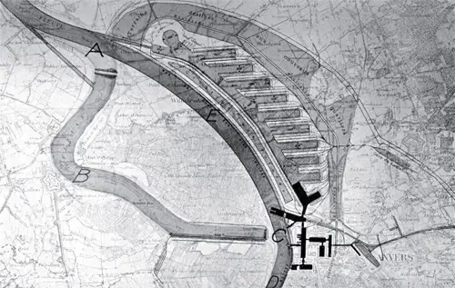
Present Dock System of Antwerp shown in black near C. Present course of River Scheldt A, B, C, D. Proposed "Grande Coupure" (great cut) in river channel A, E, C. Proposed great extension of dock system shown to the right of new river channel C, E, A.
There are 105.7 acres of sheds, mostly of the single story type, and several warehouses and storehouses. Many of the older sheds and some of the new ones are of the open type, while some of the later ones are enclosed. The new sheds are especially well built of brick, and steel, with rolling doors, and wholly fireproof.
The river quays are appropriated especially for the use of regular lines of steamers and coastwise vessels. They were built at two different dates, and are generally spoken of as the "Old River Quays", and the "New River Quays". The Old Quays were built by the State between 1878 and 1884, but the City of Antwerp provided the sheds and mechanical equipment.
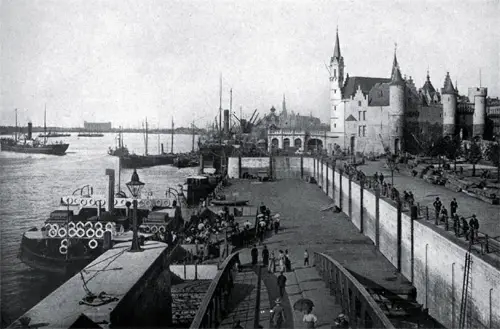
Large Floating Pontoon Similar to the "Prince's Landing Stage" at Liverpool.
At these quays there is a floating landing stage with a movable bridge for passenger service similar to those used upon the Mersey River at Liverpool.
In 1895, by mutual agreement, the State built new quays, 6,560 feet long, beyond the old quays, and here again the City provided the entire equipment. These quays were built upon a more liberal plan than the former ones, as much more room was available for this purpose. The sheds adjacent to these quays cover an area of 18.9 acres and cost $386,000.
Fifty-one "half-arch" cranes handle goods to and from these sheds and vessels. The roof of the sheds at two of the quays are built flat and in the form of a terrace or promenade, from which a splendid view of the river and shipping activities can be obtained.
The following table gives the dimensions of the Antwerp Docks :
| Name of Dock | Length (Ft) | Width (Ft) | Surface acres |
|---|---|---|---|
| Bonaparte Dock | 492 | 558 | 6.3 |
| Guillaume Dock | 1,246 | 492 | 14.4 |
| Junction on Kattendyk Dock | 279 | 164 | 1.1 |
| Kattendyk Dock | 3,149 | 459 | 33.3 |
| Kattendyk Lock Chamber | 361 | 230 | 1.8 |
| Timber Dock | 1,706 | 492 | 19.2 |
| Campine Dock | 1,148 | 525 | 13.8 |
| Asia Dock | 2,001 | 328 | 15.1 |
| Junction on Lefebvre Dock | 377 | 164 | 1.4 |
| Lefebvre Dock | — | — | 31.8 |
| American Dock | — | — | 16.6 |
| Basin Dock | 2,050 | 820 | 38.6 |
| Wet Dock, North | 1,722 | 590 | 24.0 |

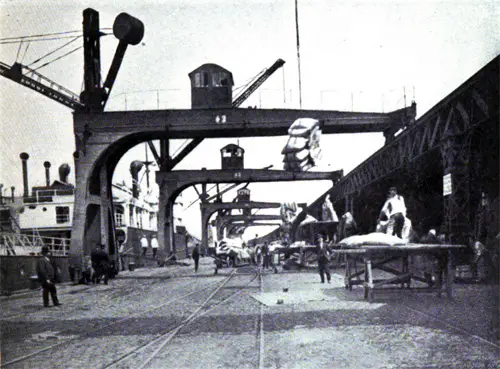
Part of New North Docks - Grain Elevators at Work. GGA Image ID # 14558f7d9d
The two new North Docks, the last ones provided, were three years in building, were opened in 1907, and cost $1,447,500, including quays, sheds and the mechanical equipment. They are known as the "Basin Canal" and the "First Wet Dock". Their widths are respectively 820 feet and 590 feet each, and the depth of water is 31.2 feet with provision for deepening it to 36 feet. The closed sheds around these docks cover an area of 3.4 acres, and the open sheds 3.5 acres.
Antwerp also possesses six dry docks which are available for all parties needing such facilities. Dues are charged in proportion to the vessel tonnage and the time the docks are occupied.
The present six dry docks are insufficient, and a new one estimated to cost, with all fittings, over $965,000 was commenced in 1910 and will probably be completed by 1913. This dock will be 722 feet long, and have a waterway of 75 feet.
There are over 156 movable hydraulic cranes of 3,308 and 4,410 pounds capacity scattered over the quays of the various docks.
The City maintains a fleet of tug boats and dredges to assist navigation and to maintain a sufficient depth of water in the river, basins, etc. The amount of dredging in 1909 amounted to 457,800 cubic yards.
There are two principal freight stations, the Antwerp Docks with 96.9, and the Antwerp South and River Quays with 66.5 miles of railroads. Some idea of the tremendous amount of business done at these stations can be gained from the fact that the average traffic of the former station is 3,500, and of the latter, 2,000, or 5,500 trucks arriving and departing from the two stations daily.
That Antwerp has been hard pressed to provide new, enlarged and better facilities fast enough to keep up with the phenomenal growth of the port can be seen from the following tables showing the rate of increase in the commerce of the port :
| Year | Number of Vessels Entered | Tonnage of Vessels |
|---|---|---|
| 1900 | 5,244 | 6,691,791 |
| 1901 | 5,209 | 7,510,938 |
| 1902 | 5,607 | 8,427,779 |
| 1903 | 5,761 | 9,131,831 |
| 1904 | 5,852 | 9,400,335 |
| 1905 | 6,034 | 9,850,592 |
| 1906 | 6,495 | 10,884,412 |
| 1907 | 6,284 | 11,181,226 |
| 1908 | 6,135 | 11,051,644 |
| 1909 | 6,470 | 11,940,332 |
This table also shows the increase in the size and carrying capacity of the vessels entering the Port of Antwerp, for while the number of vessels entered between 1900 and 1909 increased by but about 24 per cent. the tonnage in the same period increased nearly 100 per cent.
Kattendyk Dock - 3149 feet long, 459 feet wide and 33.3 feet deep.
View of the Grand Basin
Open Sheds on the River Quays
South Promenade of River Quays.
Furnishing a splendid view of shipping activities on the River Scheldt. Goods pass to and from the ships and open sheds underneath the promenade.
The growth of the Interior Traffic for the same period, follows :
| Year | Number of Vessels Entered | Net Tonnage |
|---|---|---|
| 1900 | 32,990 | 5,503,670 |
| 1901 | 32,765 | 5,795,027 |
| 1902 | 32,120 | 6,287,716 |
| 1903 | 33,940 | 6,964,328 |
| 1904 | 36,077 | 7,723,062 |
| 1905 | 36,651 | 8,155,696 |
| 1906 | 38,149 | 8,406,895 |
| 1907 | 37,302 | 8,138,864 |
| 1908 | 37,359 | 8,270,779 |
| 1909 | 39,705 | 9,003,069 |
Not content with the recent great improvements of the Port of Antwerp, the officials have now planned extensions so large and so comprehensive in comparison with the present system of docks, as to challenge the admiration of the world. The following from "The Port of Antwerp'', describes the great extensions as planned.
"To enable commerce to expand naturally and continually, the Public Powers have grasped the fact, that, however vast the present installation may be, they must be progressively enlarged and extended.
Over fully a year ago, the extension alone, about 3,280 feet of the Canal Dock, was begun, and also the construction of wet docks Nos. 2 and 3.
These new installations will increase the expansion of the quays and surface of the docks to 18,040 linear feet, and 164 acres respectively. They will involve an expenditure of something like $2,702,000 not including the quay gearing, and will take a good three years time to complete.
Before these works are finally completed, the Government will probably have started excavating the Canal Dock, some 4.35 miles in length by 820 feet in width, and also constructing some immense sea locks at Kruisschans, thus connecting the Canal Dock with the Lower Scheldt by means of a wide waterway.
In three years also from now, the building of the large Dry Dock, previously referred to herein, will be completed.
The wet docks, 9 in number, 656 feet in width by 3,936 feet in average length, are to be constructed by the City, proportionately with the increase in traffic.
The installations for small craft navigation are likewise to be enlarged and improved; a reach of the fortification moats, between the Breda Gate and the Schyn Gate will be arranged in the form of an interior barge dock.
The junction canal between River Meuse and the River Scheldt (the Campine Canal), split into a large section, will flow freely into this new dock, as well as into the Lefebvre Dock, and will, besides, conserve that part of the canal which at present flows into the Asia Dock.
The City has decided to construct a dock for Corn lighters between the two first wet docks. A scheme for arranging a dock for coasting vessels behind the d'Herbouville Quay in the South is under construction.
The various schemes will take ten years to execute, and the following table will afford some figures for comparison :
| Present day Situation | Sit. about 1920, after the various works described above have been executed. | |
|---|---|---|
| Surface of Docks | 230 acres | 1,260 acres |
| Length of Quaywalls and Slopes | 9.94 miles | 31 miles |
| Area of Sheds | 141 acres | 840 acres |
A shifting station, vast in extent, on the present territory of Merxem is in full course of construction. A large boulevard winding around the new maritime installations will shortly be laid down, and also a "Transporder" bridge, connecting the two banks of the Scheldt, will be constructed over the up-stream.
The plan for the construction of one or several tunnels under the river are being rapidly pushed forward, and the State has decided to improve the ferry communications between the 'Tete de Flandres' and the floating landing stage at the 'Canal au Sucre' by erecting a large lift, specially for hoisting up vehicles to the level of the quay at low tide.
Finally comes the scheme known as 'Grande Coupure' which would change the course of the Scheldt down stream from Antwerp; by it the present winding waterway would be replaced by a much straighter channel."
The "Grande Coupure" or "great cut", provides for cutting a new channel for the Scheldt River across a great bend just below the City. This plan would add a new River Quayage of 28,536 feet to the present River Quayage of 18,040 feet. The new docks will increase the present area, which has taken a half-century to build, by 300 per cent. and increase the quayage from 10 to 31 miles, and all of this work is to be carried out within ten years. After this work is finished, the old bed of the Scheldt, about 2 square miles, is to be converted into a great basin by means of dams, locks, gates, etc.
In view of such wonderful foresight and confidence in the future of the Port of Antwerp, is it surprising that those in charge of the development and management of rival Continental Ports should view such great extensions with more or less anxiety for the future commercial supremacy of the North Sea Ports?
View of Half-Arch Cranes on the South Quay
Fifty Ton Electric Hoisting Crane on the South Quays
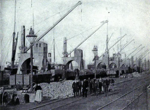
Cranes on the Campine Dock
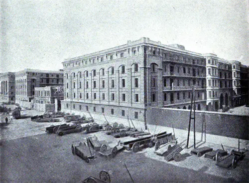
Government Bonded Warehouse

Map of the Scheldt from Antwerp to the Sea. Dr Norddeutsche Lloyd, 1892. GGA Image ID # 21604a4562. Click to View Larger Image.

The Port of Antwerp with the Seheldekais. Der Norddeutsche Lloyd, 1892. GGA Image ID # 21604cd850
Bibliography
"Port of Antwerp: Growth of the Port" in Shipping: Marine Transportation, Construction, Equipment and Supplies, New York: Shipping Publishing Co, Volume 15, No. 5, March 10, 1922 P. 40-41.
"Port of Antwerp - Progress of Overseas Traffic" in Shipping: Marine Transportation, Construction, Equipment and Supplies, New York: Shipping Publishing Co, Volume 15, No. 1, January 10, 1922 p. 43.
L. W. Alwyn-Schmidt, “Antwerp’s Pre-War and Future Status.” In The Nautical Gazette, Volume 95, No. 16, Whole No. 2488, Saturday, 19 April 1919, Page 268.
“From Correspondents: Antwerp’s Quick Revival.” The Nautical Gazette: An International Weekly Newspaper of Shipbuilding, Shipping, Marine Insurance and Export News, Volume 95, No. 15, Saturday, APRIL 12, 1919, P. 258.
“Antwerp’s Port in Good Shape.” In The Nautical Gazette, Volume 95, No. 13, March 29, 1919, Page 214.
"Antwerp's Past, Present and Future." In The Nautical Gazette, 1 February 1919.
"The Port of Antwerp. An overview of the Harbor and City" Courtesy of Leo Van Riel, Manager of the Municipal Information Office at Antwerp. circa 1913.
Presbrey, Frank, "Approach to Antwerp," in Presbrey's Information Guide for Transatlantic Travelers, Seventh Edition, New York: Frank Presbrey Co., 1911: P. 46.
Frederick L. Ford "The Port of Antwerp," in "Part II. A Study of Some Representative European Ports in the Summer of 1909", in the Report of Connecticut Rivers and Harbors Commission to the General Assembly, Hartford: State of Connecticut, 1911, p.48-52.