The Historic St. Lawrence River Route to Europe - 1948
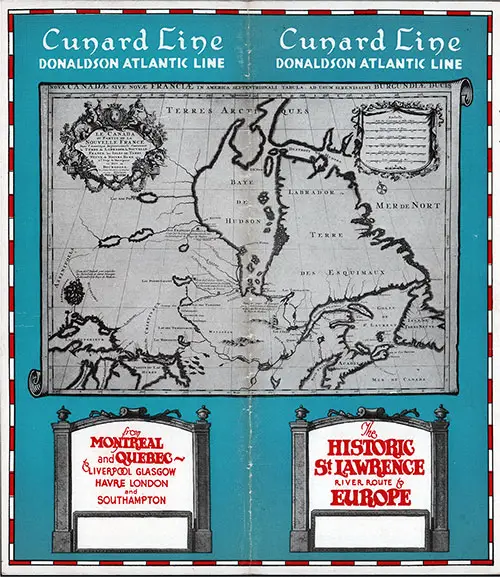
Front Cover, 1948 Brochure on the Historic St. Lawrence River Route to Europe from Montreal and Quebec to Liverpool, Glasgow, Le Havre, London, and Southampton onboard the Steamships of the Cunard Line and Donaldson Atlantic Line. GGA Image ID # 12c390e3d8
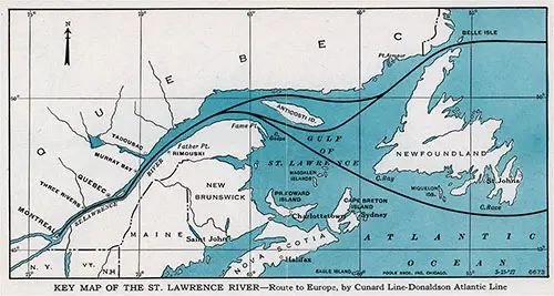
Key Map of the St. Lawrence River -- Route to Europe, bu Cunard Line-Donaldson Atlantic Line. GGA Image ID # 12c3a81942
Montreal -- The World's Greatest Inland Ocean Port
Just as the Amazon, Mississippi, and Yangtse-Kiang have been the greatest factors in developing Brazil, the Western States, and China, so the St. Lawrence River has influenced the course ol Canadian economics and commerce since the days when the Iroquois Indians watched the first bold explorers from the Old World make their way up its mighty reaches.
Today this is truer than ever before in the story of Canada's development. The world's treasures are brought to Canada's door by this greatest of rivers, and by it arc Canada's numerous resources translated into the sustenance of Europe.
Montreal is situated at the head of ocean navigation, 900 miles from the sea and is actually nearer Europe by several hundred miles than New York. It is the largest inland (non-tidal) ocean port in the world and is still growing; it is Canada's largest City with a population of well over a million and it is considered the second most important ocean port on the North American continent.
The port of Montreal holds an enviable reputation for the handling of grain in volume in expeditious fashion. The Harbor possesses a grain conveyor system, serving 27 berths by which 20 vessels can be loaded simultaneously. The port possesses some of the most enormous grain elevators in America and one of the largest cold storage plants in the world.
There is ten miles of berthing accommodation providing berths for nearly 100 ocean liners at one time with additional space for river steamers and coastal vessels.
Montreal is built on the site of an old Indian village named Hochelaga, first visited by Jacques Cartier in 1535. One hundred and six years later, in 1641, Paul Chomedv de Maisonneuve with fifty-seven followers, founded here the religious community of Ville Marie, which, because of its strategical location, soon became the headquarters for fur-trading, and whose name was changed to Montreal—after the mountain which Cartier had christened Mont Real, or Mount Royal, a century before.
For many years the early settlers were at constant warfare with the Indians, and their heroism, in the face of terrible hardships, is commemorated in the beautiful Maisonneuve Monument erected on Place D'Armes Square, in memory of Maisonneuve and his gallant band ot pioneers.
Among places of special interest to visitors arc the Church ol Notre Dame, built in 1824 on the site of an earlier structure, and one of the finest examples of Gothic architecture in America; St. James' Cathedral, an exact replica of St. Peter's in Rome, and a quarter its size; the Chateau de Ramezay, a treasure house of historical relics erected in 1704 by the then Governor of Montreal.
It was where Benjamin Franklin set up his printing press in its vaults; Bonsecour Market, typical of French Canadian provincial life and like nothing else in America; Mount Royal, one of the most beautiful city parks in Canada; McGill University and the Université de Montreal; St. Joseph's Oratory, where the late Brother André is said to have effected many miraculous cures.
Today, the scenic beauty and charm ol Montreal, and its historic interest, are drawing an increasing number ol American visitors to the city each summer; while in winter, thousands of people come up from the South to engage in its winter sports of snowshoeing, skiing, tobogganing on Mount Royal, skating and sleighing.
St. Lambert lies across the St. Lawrence, on the South Shore and is a thriving, attractive, residential City. It is connected with Montreal by the magnificent Victoria Jubilee Bridge which leads the motorist on to the main highway to Albany and New York. Not far southwest is Chateaufluay, originally Indian, which figured in the War of 1812..
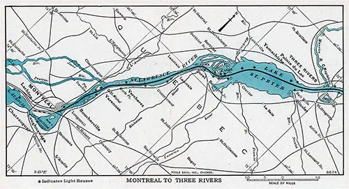
Map of St. Lawrence River, Montreal to Three Rivers. GGA Image ID # 12c3b1b567
Montreal to Three Rivers
After the ship lias left the Cunard Donaldson Atlantic piers in Montreal Harbor, it proceeds downstream passing beneath the imposing Jacques Cartier bridge which connects the island of Montreal with the City of Longueuil on the South Shore. Here was once a fort built in 1689 to protect the seicneury from the marauding Iroquois. The first seigneur was Charles Lemoine, who was made a baron in 1700 under the French Regime.
Boucherville (South) village was a seigneurv granted in 1672 to the Governor of Three Rivers. Twenty-three years later a terrible Iroquois massacre occurred here, but, as il in poetic justice, it was in this village that the first Indian child in Canada was baptized by the Jesuit missionary, Pcre Marquette. Bouchcrville's old manor-house, where the good Father lived, may still be seen.
Fort Chumbly is situated on a promontory of the Richelieu River. It was first built ol wood and palisades in 1665, by Jacques de Chambly, as a defense against the Iroquois. During its eventful history, it was burned by the Iroquois in 1702 and rebuilt of stone seven years later.
Varennes (South)—In fair, flat meadow-land on the same side of the river lie Varennes and Vcrchcrcs. In the former, the Parish Church, with its two towers, is one of Quebec's most beautiful churches. On the outskirts of the town is the manor-house where Madame Youville established the order of the Grey Nuns.
Verchères, also on the south, is famous in history. By an old fort near the water stands the statue oi Madeleine de Verchèrcs. This heroic girl, aged only fourteen, in 1692 successfully defended the manor-house. Her father and his staff being absent, she was aided only by two young boys and an old man of over eighty, against an Iroquois attack which lasted for a full week. The statue is the work of a famous French sculptor, and may be seen from the river.
Sorel (South) is on the banks of the great Richelieu River, a St. Lawrence tributary. Its history links Canada with the United States. The town was founded by Pierre de Sorel, a French military engineer, who built a fort here in 1665, and for some time was the summer home of the Governors of Canada. In Sorel was established the first Protestant (Anglican) church in Canada.
Beyond Sorel the river widens out into Luke St. Peter. This is one of the most beautiful parts of the St. Lawrence, and the numerous picturesque islands at the entrance to the lake are favourite haunts for duck-shooting. These islands were used as ambushes by the marauding Iroquois in the early colonist days.
Fort Crevier (South) a militarv fort at the mouth of the St. Francis River, and now Notre Dame dc Pierrevillc. It was erected in 1687 as a protection against the Indians from (he south, and battles were fought there in 1689 and 1695.
Nicolet (South) possesses one of the oldest houses in the country, besides being a cathedral town.
Yumuchiche (North) is almost opposite Nicolet and is surrounded by magnificent farm land. The Parish Church strikes a quaint note in this ancient hamlet. Nearby are the giant wireless towers of the beam system of transmitting wireless messages across the Atlantic.
Pointe du Luc (North) is nearby, a pleasant settlement and a favourite resort in summer for Three Rivers. During the invasion of Canada in 1775, by the American forces, this village figured in an exciting skirmish.
Three Rivers (Trois Rivières) (North) is at the mouth of the St. Maurice River, from whose three outlets this prosperous, thriving city derives its name. It has a good harbour and the first tidewater. A mission and trading-post was established here in 1617, the town being founded in 1654 with a fort to protect it. The settlement was almost destroyed by the Iroquois m 1655, and the post was used a great deal by trading Indians from the north.
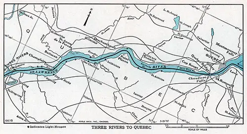
Map of the St. Lawrence River, Three Rivers to Quebec. GGA Image ID # 12c3e35c5a
Three Rivers to Quebec
Champlain (North) was founded in 1679, and is still as calm and peaceful as it was over 200 years ago. Here begin the first of the red cliffs, with the blue hills behind.
Cap La Roche (South) is a signal station devised to indicate to ship-masters and pilots the depth of water in the channel. In this neighborhood Jacques Cartier made his winter headquarters on his second trip to Canadian shores. Near here stone cliffs appear, and in the distance rise faintly the Laurentian Mountains. Along the shore are old manor-houses which figured in the American invasion of 1775.
Batiscan (North) lies at the mouth of the Batiscan River, which runs down from the rich, unexploited hinterland of Quebec.
Ste. Anne de ta Pérade and Deschambault are visible further down on the same side, half-way between Quebec and Three Rivers.
Cap Rouge (North), the first settlement in which women and children took part. It was established by Rol>crva! in 1542, the year before Jacques Cartier wintered here on his third voyage to Canada.
Soon we approach the Quebec Bridge, which is regarded as one of the world's greatest engineering achievements, completed in 1917, after two previous unfortunate attempts. It has a long clear centre span, measuring 1,800 feet, approximately 153 feet above the high water level. As the ship approaches the bridge, an optical illusion is created, whereby it seems impossible for the tall masts of the shin to pass under the bridge. The fact that the masts do clear the bridge, however, is always a matter of wonderment to the watching passengers.
On the south shore here, enters the Chaudière River, down which, during the Revolution, American forces under Benedict Arnold went to join Montgomery's forces before assaulting Quebec. Nearby is the typically French village of Saint Romuald, possessing an interesting church.
Sillery (North) is an ancient village founded in 1637, quite close to the frowning rock of Quebec. It has an old manor- house and a monument to the first Jesuit missionary.
Wolfe's Cove (North) now the site of a modern terminal, is where, on September 12th in 1759, the British General Wolfe landed with picked men, the night before the successful storming of the city of Quebec, which was held by French forces under General Montcalm. During the summer of that year, the British had besieged Quebec, landing above and below the city but unable to approach the Citadel.
The struggle was intensified by the occasional shelling from the heights of Levis opposite, and once the French tried to set Wolfe's fleet on fire by sending burning ships downstream.
Fearing attack from the steep cliffs, the French had no idea their enemy would land farther upstream and attack the city from the rear. The landing at Wolfe's Cove was successfully and speedily carried out. Wolfe himself led the troops, proceeding in boats a little after midnight, under a clear sky and with muffled oars. Where they landed is now called Wolfe's Cove, in memory of that night. Making their way quietly up the narrow ravine to the top of the cliffs, they overpowered the French sentries. By morning the British had gathered 4,500 men on the Plains of Abraham. So surprised were the French that when the British appeared on that hateful morning, Montcalm is said to have exclaimed "What, have they wings ... !" Both generals were mortally wounded in the battle which followed. In the fine park in Quebec, laid out on the commanding site of the Plains of Abraham, a monument testifies to the courage and resource of both great soldiers.
Opposite is Pointe du Planton (South) built on picturesque little terraces.
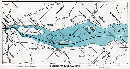
Map of the St. Lawrence River, Quebec to Murray Bay. GGA Image ID # 12c3facedd
Quebec to Murray Bay
Quebec is one of the oldest and most picturesque cities in the New World. Dramatically it overshadows, on its rocky heights, the swift, historic river from which it presents an almost medieval appearance. Quebec was founded in 1608 by Samuel dc Champlain, on the site of the Indian village of Stadacona. Through a long, varied, and colorful history, Quebec was the very cradle of Canada's civilization. In 1629 the city was captured by the British, remaining in their hands for five years, then restored to France by treaty. In 1759 the battle of the Plains of Abraham, won by Wolfe against Montcalm, finally gave Quebec (and Canada) to the British. In 1775 American revolutionary forces under Montgomery and Arnold attacked the city, but were defeated by British troops and local militia under Sir Guy Carleton.
The famous Citadel at the top of the rock commands the St. Lawrence for many miles. The ramparts, the high gabled roofs, lofty spires, and narrow, climbing streets, give Quebec the charm of an Old World fortress city.
The pilots serving between Montreal and Quebec leave the outward ship here, and the Father Point pilot embarks.
Levis, on the opposite side of the river, is its twin-sister city. From its lower heights Wolfe's artillery pounded the opposite city prior to the battle. The view from these heights is magnificent, Levis is also noted for its dry docks.
Isle of Orleans—This fertile island was called the "Isle of Bacchus" by Cartier, on account of the profusion of grapes which grew on its shores. In 1759, before Quebec was captured, Wolfe's forces camped here, the French troops being on the mainland opposite.
Montmorency Falls can be glimpsed from the ship's deck just before it passes along on the south side of the island. These magnificent falls are over 100 feet higher than Niagara Falls. Kent House was once the residence of Queen Victoria's father.
Ste. Anne de Beaupré is on the north shore, not visible from the ship because of the Isle of Orleans, and is one of the world's most famous shrines. Each year it is the scene of many miraculous cures, and thousands of pilgrims journey there every summer. The famous basilica was burnt down some years ago and the temporary Church used during the construction of a new basilica was also destroyed by fire in 1926. Although many of the relics and treasures were lost, the famous relic of Saint Anne was saved from the fire. The imposing structure now standing on the same site, is but partially completed.
St. Francois is near the east end of the island. It was first built in 1683, and legend has it that on Isle Madame nearby early adventurers buried their treasure.
The ship now enters channels known as the South Traverse and the Beaujcu, between Crane Island and the south mainland.
Montmaüny (South) is a thriving town named after a governor of the early days.
Cape Tourmente (North)—Here the bank of the river rises over 1,800 feet into the promontory known as Cape Tourmente, the first of a number of similar capes stretching away northeastward.
Baie St. Paul (North) is a pretty village set on the summit of the rocky heights with several capes towering up around it.
Isle aux Coudres—An island off shore, of volcanic origin, which figured in the British campaign of 1759.
Les Eboulements (North)—The center of considerable volcanic disturbance in the early days of the colony. The life of the inhabitants is typically French Canadian.
Ste. Anne de la Pocatiere (South)—A dramatically situated village with a magnificent church and Catholic college, on the main road from Quebec to the Maritime Provinces.
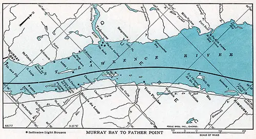
Map of the St. Lawrence River, Murray Bay to Father Point. GGA Image ID # 12c434bbd7
Murray Bay to Father Point
Pointe au Pic (North) is now one of the most fashionable summer resorts on the St. Lawrence, better known as Murray Bay. It was originally named Malbaie, because of the dangerous tides, and was visited by Champlain in 1608. The annual influx of tourists has not spoiled the simple beauty of this French Canadian village. Overlooking the bay is a magnificent hotel with golf courses, visited by hundreds of tourists each summer.
Kamouraska (South) is quite an important town on the south shore, and is frequented by summer visitors.
Rivière du Loup is the most important town on the south shore. It was so named from the great number of seals (loups- marins) which used to frequent its shores in the early days. For many years its name was changed to Fraserville, in honour of its Scotch seigneur. Quite close are the pretty summer resorts of Cacouna, St. Patrick, and Notre Dame de Portage.
Tadoussac lies on the north shore, at the mouth of the Saguenay River, which flows down from one of the richest mining areas in Canada, now being opened up. Volumes might be written on this ancient town, which was an Indian fur-trading post, and was first visited by Cartier in 1535. Tadoussac is supposed to have been visited much earlier than this date by Breton and Basque sailors, and possibly even before then by Norse adventurers. From the time of Cartier, the Port of St. Malo, in France, traded constantly with Tadoussac, and some of the chief traders were relatives of the explorer. Champlain was here in 1602, and in 1628, the fort was seized by Sir David Kirke. The garrison was massacred by Indians in 1661, and the Jesuits had control up to 1782. Charlevoix relates that in 1670 there were rarely less than 1,200 Indians to be seen encamped at Tadoussac.
The river is 700 feet deep, and its precipitous banks rise 1,600 feet above the water, in scenery of a solemn grandeur unsurpassed on this continent. The majestic Capes Eternity and Trinity are names well-known all over America.
Up the mighty Saguenay which is navigable for ships of any tonnage as far as Chicoutimi, lies Lake St. John into which pour scores of great streams from the vast rich hinterland of Quebec Province. Chicoutimi is the center of one of Canada's largest paper pulp industries, and is the scene of important new power developments. Other towns of increasing importance arc Jonquierc, Robcrval, Arvida also Port Alfred, a comparatively new port through which large quantities of paper and aluminum are handled everv year.
Trois Pistoles (South) was founded at the beginning of the eighteenth century. The name of it is said to be derived from the answer of a fisherman, "Trois pistoles," to a hunter who had asked him how much he would charge to take him across the river.
Bic (South) was the scene of a horrible Indian massacre over 250 years ago.
Rimouski (South) is a very picturesque town dating from 1701. Rimouski suffered heavy damage from the disastrous fire which occurred in 1950. Its beautiful Cathedral and Bishop's Palace still may be seen from the river but the adjacent college buildings were destroyed.
Father Point (Pointe au Père) (South), where a government wharf and lighthouse arc situated. The village was named after Père Nouvel, who first came to this spot in 1665, and it was afterwards known to rivermen as a place of worship and pilgrimage.
From the pilot station, the river pilots join inward-l>ound ocean ships to take them to Quebec, and here, the outbound liners drop the pilots embarked at Quebec. Opposite Father Point, Bersimis Point and its light, well-known to river navigators, arc seen. The liner, after the pilot leaves her, follows the Gaspc Coast ciuite closely. Several picturesque villages arc seen, the chief of which are Métis and Matane, at the mouth of the Matane River.
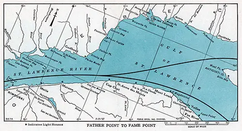
Map of the St. Lawrence River, Father Point to Fame Point. GGA Image ID # 12c47b8d44
Father Point to Fame Point
Godbout (North), an old French trading post established before 1670.
Cap Chat (South) is a notable high cape which was mentioned in Champlain's records three centuries ago. The country behind the cape is an excellent agricultural region.
Ste. Anne des Monts (South) is the next settlement. At the back of the town is a hilltop on which is visible a gilt cross erected to the memory ol the patron saint of seamen. This hilltop, Mont Ste. Anne, is one of the first landmarks sighted by ships coming up the river from the Gulf.
Seven Islands (North), wasoneof the earliest of theold "King's Posts" and was established about 1650. The islands arc famous for their beauty, and the Indian Reserve is of interest to visitors.
Mont Louis (South) is one of the prettiest villages set at the foot of surrounding hills, 'file villagers' occupations arc, for the most part, lumbering and fishing.
Cap Magdeleine (South) was first established by the Jesuits in the seventeenth century, near the River Magdefeinc, famous for salmon fishing. From the ship only a few houses and the flagstaff of the signal station arc visible.
Along the coast here are five old seigneuries granted by the King of France to settlers, as far east as Fox River. The occupation of the inhabitants is fishing, and one or two coastal points distribute lumber for the inland region. The only means of transportation in this area is by coast steamer, which makes intermittent calls, the freight being brought out in launches. The largest of these points is Grande Vallée, which is almost opposite the western end of Anticosti Island.
Fame Point (South), with its red-roofed white houses and cheerful church is the last signal station on this coast, fronting on the Gulf of St. Lawrence.
Fox River (South) is one of the last fishing communities on the Gaspé Coast, which we see from the ship. Farther south, but out of sight, is the ancient town of Gaspé.
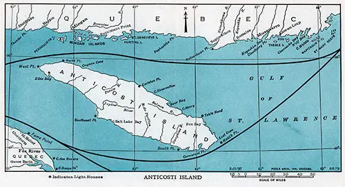
Map of Anticosti Island at the Gulf of St. Lawrence. GGA Image ID # 12c4a35462
Anticosti Island
Anticosti
Ocean liners have a choice of two routes, one passing between the North shore of Anticosti and the Quebec mainland, and on through the Strait of Belle Isle, and the other route passing between the South shore of the Island, and the Coast and Islands of the Maritime Provinces, continuing either along the South coast of Newfoundland, or proceeding North into the Strait of Belle Isle, and so to the open sea.
Anticosti was for over thirty years the property of a French family, the head of which was Senator Menier, the well-known French chocolate king. Some years ago the whole island was acquired by pulp and paper interests who are now developing the forest resources of the island. Anticosti is one of the most fertile islands in the North American continent, and it is estimated that its forest resources will provide some 15,000,000 cords of pulp- wood. The island has an area of 3,100 square miles, approximately 2,000,000 acres.
West Point is almost 400 miles from Quebec, 45 miles north of the Gaspé Coast, and 2,400 miles from Liverpool or Southampton.
Mingan, a trading post on the North mainland, was established in 1665, as the head of a seigneury. This seigneury was under private ownership until 1950, when the rights which had been the subject of much legal conflict were acquired by the Quebec Provincial Government as the first step in opening up what is believed to be fabulously rich mining resources, a short distance inland.
Natashquan, a few miles East, is an old trading post built before 1710. Most of these posts are at the mouths of small rivers, and this one is no exception.
Romaine and Musquarro, also on the mainland, are other French posts established in 1710, in territory leased to the Labrador Company of Quebec in 1780.
On the southern Anticosti route, the liner passes South Point and Heath Point on its way to Belle Isle.
Some distance to the south lie the Magdalen Islands, Cape Breton Island, Prince Edward Island, and, to the southwest, the coast line of Nova Scotia and New Brunswick. To the southeast is Cape Ray, Newfoundland; to the east the rugged coast of Britain's oldest colony.
The Early History of the St. Lawrence River
ALTHOUGH the first record we have of the navigation of the St. Lawrence is that of 1508, when Aubert, a Dieppe seaman, sailed up as far as Tadoussac, European navigators may have discovered the gulf and the river mouth centuries before, ft is probable that Normans and Basques knew these waters in the eleventh and twelfth centuries, trading with the Indians for furs. There is also evidence that the Vikings in the tenth century founded a fishing station at Gaspé, and probably explored the gulf and the river for a considerable distance.
The recorded history of the river proper starts with Jacques Cartier, who, in the month of April, 1554, left St. Malo in North France and reached the Bay of Chaleur, sailing along the Anticosti shores during the summer of that year, 'flic next year he left France on a second voyage, and in July entered the Strait of Belle Isle, where he sought shelter in a small harbour, which he christened the Bay of St. Lawrence.
This is the first appearance in Canadian history of the name which was later to he applied to the great river and gulf. The mighty stream intrigued Cartier very much from the first. An idea of what the Indians thought of it may he gained from the reply of an Indian whom Cartier asked what river it was, and who told the explorer that it was a "river without end.''
Later in that year Cartier reached the Saguenay, and then Stadacona, which is now Quebec. In the fall he sailed as far as Hochelaga, now Montreal, and was welcomed by the Indians there. Returning to Stadacona, he took the Indian king with four chiefs hack to France with him. In 1541, Cartier sailed again from France at the command of Francis I. On this third voyage to Canada, Cartier consolidated the progress he had made in former visits. The next year the first colonists, 200 in number, arrived from France under Sieur de Roherval. They settled at Cape Rouge, a few miles above Quebec city.
In 1600 a merchant of St. Malo, named Pont Grave, made two successful voyages to the St. Lawrence, ascending it as far as the St. Maurice River, and in 1603 he and Sieur de Monts, a courtier of Henry IV, obtained the exclusive right to trade in the territory between the 40th and 54th parallels of latitude. In this same year Samuel dc Champlain, a captain in the French Royal Navy, thirty-six years of age, left with a commission from the French king to found an empire across the sea. He returned to France and the following year came back again with De Monts. They entered the Bay of Fundy and built a fort at the mouth of the St. Croix River. Champlain went back to France the next year, and in 1608 returned and founded Quebec. This marked the beginning of the purposeful development of New France.
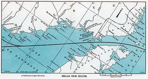
Map of St. Lawrence Seaway -- Belle Isle Route. GGA Image ID # 12c51239ca
Belle Isle Route
This route is open to trans-Atlantic liners between the end of May and early November. To the north is the coast of Quebec and Labrador, and to the south is that of Newfoundland.
St. Augustin (North) was another one of the old fortified posts, and is now a busy trading point.
St. Paul's River, a few miles farther toward the Labrador boundary, was once an ancient French fort called Fort Pont-chartrain, at the mouth of Eskimo River. It was built about 1630 by Courtcmanche, to whom the original grant of land was given that year.
Bonne Espérance, on Bradorc Bay, is the most easterly point in Quebec Province, and is at the western limit of the Strait of Belle Isle. It used to be called Baie Phelypcaux, and was an ancient French fort built by Courtcmanche in 1702. The Courtcmanche family retained and exercised privileges of the grant land until after 1759. Cartier visited this bay, according to his records.
Greenley Island—Just north of the ship route arc two islands; the westerly one is Greenley Island, now famous throughout America as being the landing place of the Bremen, first aeroplane to make the westward crossing of the Atlantic. This lonely isolated island was the centre of interest for two continents after the historic crossing had been made.
Forteau Bay near Pt. Amour, is the first point in Labrador at the western entrance of the Strait of Belle Isle, and was another old French trading post fortified by Courtcmanche long before 1650. However, the Basques had long ago maintained an establishment here for their whale fisheries.
Red Bay is half way through the Strait on the Labrador Coast, and was established before 1700 as a trading station.
Chateau Bay is the last point on the mainland seen from the ship before clearing the Strait to the open sea. It was visited in
1534 by Cartier and appears on maps as early as 1543. Much trading was done here with the Eskimos. The name "Chateau" was derived from the resemblance of a mass of basalt which caps an island in the Bay to a Norman keep. Finally the ship passes between Belle Isle and Cape Bauld into the open Atlantic.
Labrador takes its name from a Basque fisherman called Bradore, who is said to have settled in Bradorc Bay almost 1520. The Straits were charted by Cartier in 1534, and soon became the busy center of a fishing area. France used to maintain a garrison of 500 men at Bradorc, but abandoned it in 1760 because of sea raids made on it during the warfare prior to Quebec's surrender. Labrador has since successively been placed under the jurisdiction of Newfoundland, of Canada again, and, in 1809, of Newfoundland once more. It is still subject to Newfoundland, and the question of boundaries is now definitely decided in favor of that colony. Possessing no government of its own, justice is meted out by missionaries and medical men who labor in its settlements. The shallows off the Labrador Coast harl>our great shoals of cod. 'flic coast itself is fringed with bare islands and jagged rocks, while the scenery is wild and rugged. Inland, the great plateau shows marks of pre-historic placiers, and its forest lands are among the finest game areas in North America.
The Newfoundland Coast is very wild, and, save for a few small settlements, is uninhabited. As the ship nears the open sea the Strait becomes narrower, until finally Cape Norman appears on the Newfoundland side, and further cast, the ship passes the island of Belle Isle, which gives its name to the Strait.
The Belle Isle route to Europe is the shortest available from North America. It reduces the ocean portion of the voyage by two or three days for Belle Isle Strait is nearly 1.000 miles from Montreal. It is not open for the entire St. Lawrence navigation period but when used, shortens the journey from Montreal to Europe by almost a day.
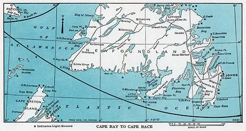
Map of the Gulf of St. Lawrence, Cape Ray to Cape Race. GGA Image ID # 12c54d8e9f
Cape Ray to Cape Race
Cape Ray—The alternative route from the south of Anticosti is along the South coast of Newfoundland. The ship passes Cape Ray and the Newfoundland town of Port-aux-Basques, immediately opposite Sydney, N. S., which of course is not visible from the ship. For some time the coast of Newfoundland is invisible, but land is again passed when the ship nears Great and Little Miquelon Islands and the Island of Saint Pierre.
These three islands are called the Miquelon Group, and, of the great American Empire once ruled over by France, arc the last vestiges. The whole group possesses a total area of about eighty- one square miles, and a population of 4,500, more than nine-tenths of whom live on Saint Pierre. The islands arc well worth visiting when opportunity offers, and are only twelve miles from the Burin Peninsula of Newfoundland.
Saint Pierre is a genuine bit of old France, whose people are as sturdy fishermen as were their ancestors, over 200 years ago. Saint Pierre lives on the great cod fisheries of the banks. It has belonged to France since 1660, in spite of three successive British invasions; under the treaty of Paris it once more passed into French possession, in 1852.
Sailing then due east the ship cuts across Placentia Bay, which runs into the very heart of Newfoundland, finally nearing land again at Cape Pine, and, for the last time, Cape Race.
Northwards, on the eastern coast of Avalon Peninsula, is St. Johns, capital and seat of the Provincial Government of Newfoundland. From this city a railway runs through tlie island to the west coast, linking up the town and settlements of the coast and the interior, including the towns of Harbor Grace, Placentia, Carlxmear, Lewisport, Bay of Islands, and Port-aux-Basques.
Cape Race, a signal station, is the last point of America seen from the eastbound ship on this route.
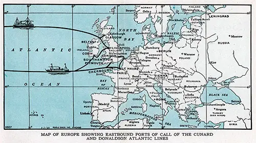
Map of Europe Showing Eastbound Ports of Call of the Cunard and Donaldson Atlantic Lines. GGA Image ID # 12c56f9892
FREQUENT sailings between Montreal (and Quebec) and the ports shown in the above map are maintained by six shins of the Cunard and Donaldson Atlantic Lines. These ships arc the popular 20,000 ton Cunarders, FRANCONIA, of world cruising fame, SCYTHIA and SAMARIA also the 14,500 ton ASCANIA and the Donaldson Atlantic vessels, LAUREN- TIA and LISMORIA. Services are provided to and from Liverpool, London, Southampton and Havre by Cunard ships and to Glasgow by the Donaldson liners.
These ships, all oil burning, arc modern in appointments and furnishings. All carry first and tourist class passengers except the LAURENTIA and LISMORIA which carry first class only. For service, these ships arc as famous among the increasing number of Americans who choose the historic St. Lawrence Route to Europe as they are among Canadians.
Cunard service has a historic foundation, for it dates back to the year 1840, when, with the sailing of the stout little BRITANNIA from Liverpool to Halifax and Boston, the Cunard Line inaugurated the first regular steamship service across the Atlantic —a service which has been maintained uninterruptedly since then.
The founder of the line, Samuel Cunard (afterwards knighted), was a native of Halifax, N. S. In 1839 he organized in Britain, despite great difficulty and much opposition, a steamship company which has developed into the magnificent enterprise known today as the Cunard Line, with its associated companies. The history of the Cunard Line has largely been the history of trans-Atlantic steam shipping.
The service on the Cunard Canadian ships is a reflection of this background of over 110 years of sea service. It is supplemented by the ships of the Donaldson Atlantic Line, which, since the days of sailing vessels, has upheld a fine Scotch tradition for service on the high seas. The new LISMORIA and LAURENTIA are two popular ships with a strong appeal to Canadians and Americans of Scottish descent also to those travelers who wish to commence their tour of Europe with a visit to Scotland.
The increasing popularity of the St. Lawrence River Route from Montreal to Europe is due to certain definite attractions. To begin with, the distance from Montreal to Great Britain is shorter by several hundred miles than the route from New York or Boston. This means a shorter trip and more time to spend in Europe.
Furthermore, a third of the voyage is made on the calm waters of the river and gulf. This gives passengers time to get their sea-legs before reaching the open Atlantic, and also shortens the ocean trip by two days or more.
Again, travelers from parts of Canada outside the province of Quebec, and from all sections of the United States, have an excellent opportunity of seeing French-Canada en route to Europe. It is like adding to their itinerary a new country, with all the delightfully strange customs, sights, and idioms of language, of a people and civilization entirely different from that of any other part of America.
And if the St. Lawrence River Route is a fascinating prelude to a visit to Europe, it is equally satisfying to travelers as a sequel to their Westbound voyage from the Old World to the New. The last two or three days on calm water from Belle Isle or the Newfoundland capes to Montreal give passengers ample leisure to make their preparations for the land journey home.
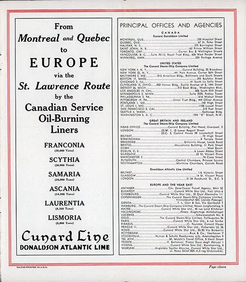
Principal Offices and Agencies - Cunard Line--Donaldson Atlantic Line. GGA Image ID # 12c58ac03b
